You are here: Home > Network List > US - United States National Seismic Network Stations List
> Station TZTN Tazewell, Tennessee, USA > Earthquake Result Viewer
TZTN Tazewell, Tennessee, USA - Earthquake Result Viewer
| Earthquake location: |
Easter Island Region |
| Earthquake latitude/longitude: |
-26.6/-114.5 |
| Earthquake time(UTC): |
2014/09/06 (249) 06:53:13 GMT |
| Earthquake Depth: |
10 km |
| Earthquake Magnitude: |
6.1 MB |
| Earthquake Catalog/Contributor: |
NEIC PDE/NEIC COMCAT |
|
| Network: |
US United States National Seismic Network |
| Station: |
TZTN Tazewell, Tennessee, USA |
| Lat/Lon: |
36.54 N/83.55 W |
| Elevation: |
394 m |
|
| Distance: |
69.3 deg |
| Az: |
26.253 deg |
| Baz: |
209.451 deg |
| Ray Param: |
0.05577023 |
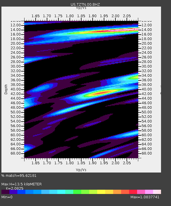
| Estimated Moho Depth: |
13.5 km |
| Estimated Crust Vp/Vs: |
2.08 |
| Assumed Crust Vp: |
6.476 km/s |
| Estimated Crust Vs: |
3.11 km/s |
| Estimated Crust Poisson's Ratio: |
0.35 |
|
| Radial Match: |
95.62181 % |
| Radial Bump: |
374 |
| Transverse Match: |
88.317535 % |
| Transverse Bump: |
400 |
| SOD ConfigId: |
790520 |
| Insert Time: |
2014-09-20 07:55:16.108 +0000 |
| GWidth: |
2.5 |
| Max Bumps: |
400 |
| Tol: |
0.001 |
|
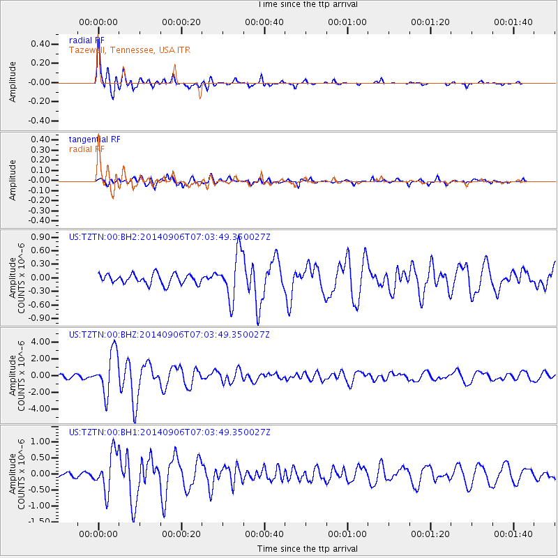
Signal To Noise
| Channel | StoN | STA | LTA |
| US:TZTN:00:BHZ:20140906T07:03:49.350027Z | 11.797056 | 2.5564389E-6 | 2.1670141E-7 |
| US:TZTN:00:BH1:20140906T07:03:49.350027Z | 8.411919 | 6.354705E-7 | 7.554406E-8 |
| US:TZTN:00:BH2:20140906T07:03:49.350027Z | 4.856423 | 5.3079145E-7 | 1.0929679E-7 |
| Arrivals |
| Ps | 2.3 SECOND |
| PpPs | 6.2 SECOND |
| PsPs/PpSs | 8.6 SECOND |


