You are here: Home > Network List > UU - University of Utah Regional Network Stations List
> Station JLU Jordanelle, UT, USA > Earthquake Result Viewer
JLU Jordanelle, UT, USA - Earthquake Result Viewer
| Earthquake location: |
Easter Island Region |
| Earthquake latitude/longitude: |
-26.6/-114.5 |
| Earthquake time(UTC): |
2014/09/06 (249) 06:53:13 GMT |
| Earthquake Depth: |
10 km |
| Earthquake Magnitude: |
6.1 MB |
| Earthquake Catalog/Contributor: |
NEIC PDE/NEIC COMCAT |
|
| Network: |
UU University of Utah Regional Network |
| Station: |
JLU Jordanelle, UT, USA |
| Lat/Lon: |
40.60 N/111.45 W |
| Elevation: |
2285 m |
|
| Distance: |
66.9 deg |
| Az: |
2.487 deg |
| Baz: |
182.925 deg |
| Ray Param: |
0.057281207 |
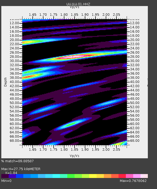
| Estimated Moho Depth: |
27.75 km |
| Estimated Crust Vp/Vs: |
1.84 |
| Assumed Crust Vp: |
6.155 km/s |
| Estimated Crust Vs: |
3.345 km/s |
| Estimated Crust Poisson's Ratio: |
0.29 |
|
| Radial Match: |
89.88587 % |
| Radial Bump: |
400 |
| Transverse Match: |
85.873924 % |
| Transverse Bump: |
400 |
| SOD ConfigId: |
790520 |
| Insert Time: |
2014-09-20 07:55:54.967 +0000 |
| GWidth: |
2.5 |
| Max Bumps: |
400 |
| Tol: |
0.001 |
|

Signal To Noise
| Channel | StoN | STA | LTA |
| UU:JLU:01:HHZ:20140906T07:03:34.859976Z | 14.996514 | 5.4513855E-8 | 3.6351018E-9 |
| UU:JLU:01:HHN:20140906T07:03:34.859976Z | 6.4104 | 1.8837667E-8 | 2.9386102E-9 |
| UU:JLU:01:HHE:20140906T07:03:34.859976Z | 2.674974 | 7.6297955E-9 | 2.8522875E-9 |
| Arrivals |
| Ps | 3.9 SECOND |
| PpPs | 12 SECOND |
| PsPs/PpSs | 16 SECOND |


