You are here: Home > Network List > TA - USArray Transportable Network (new EarthScope stations) Stations List
> Station A04D Lummi Island, WA, USA > Earthquake Result Viewer
A04D Lummi Island, WA, USA - Earthquake Result Viewer
| Earthquake location: |
Off Coast Of Jalisco, Mexico |
| Earthquake latitude/longitude: |
18.8/-107.0 |
| Earthquake time(UTC): |
2014/09/06 (249) 19:23:00 GMT |
| Earthquake Depth: |
18 km |
| Earthquake Magnitude: |
5.9 MWB |
| Earthquake Catalog/Contributor: |
NEIC PDE/NEIC COMCAT |
|
| Network: |
TA USArray Transportable Network (new EarthScope stations) |
| Station: |
A04D Lummi Island, WA, USA |
| Lat/Lon: |
48.72 N/122.71 W |
| Elevation: |
13 m |
|
| Distance: |
32.4 deg |
| Az: |
340.479 deg |
| Baz: |
151.453 deg |
| Ray Param: |
0.078652315 |
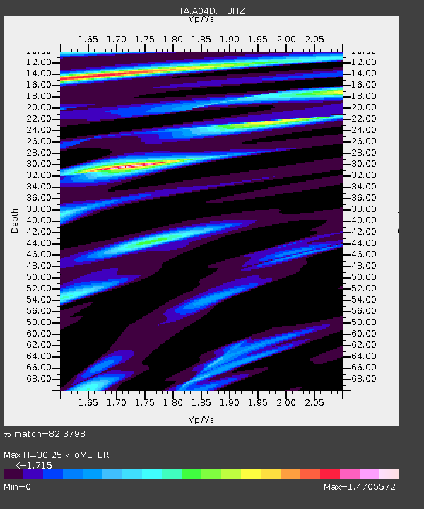
| Estimated Moho Depth: |
30.25 km |
| Estimated Crust Vp/Vs: |
1.72 |
| Assumed Crust Vp: |
6.566 km/s |
| Estimated Crust Vs: |
3.829 km/s |
| Estimated Crust Poisson's Ratio: |
0.24 |
|
| Radial Match: |
82.3798 % |
| Radial Bump: |
323 |
| Transverse Match: |
65.45493 % |
| Transverse Bump: |
400 |
| SOD ConfigId: |
790520 |
| Insert Time: |
2014-09-20 19:48:54.771 +0000 |
| GWidth: |
2.5 |
| Max Bumps: |
400 |
| Tol: |
0.001 |
|

Signal To Noise
| Channel | StoN | STA | LTA |
| TA:A04D: :BHZ:20140906T19:28:58.000002Z | 3.9575033 | 3.5755394E-7 | 9.034836E-8 |
| TA:A04D: :BHN:20140906T19:28:58.000002Z | 1.3224804 | 1.8810238E-7 | 1.4223453E-7 |
| TA:A04D: :BHE:20140906T19:28:58.000002Z | 1.1667 | 2.1832447E-7 | 1.871299E-7 |
| Arrivals |
| Ps | 3.6 SECOND |
| PpPs | 11 SECOND |
| PsPs/PpSs | 15 SECOND |


