You are here: Home > Network List > TA - USArray Transportable Network (new EarthScope stations) Stations List
> Station J61A Chester, VT, USA > Earthquake Result Viewer
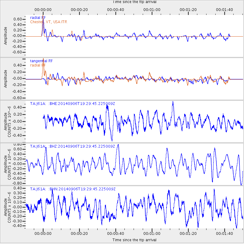
J61A Chester, VT, USA - Earthquake Result Viewer
*The percent match for this event was below the threshold and hence no stack was calculated.
| Earthquake location: |
Off Coast Of Jalisco, Mexico |
| Earthquake latitude/longitude: |
18.8/-107.0 |
| Earthquake time(UTC): |
2014/09/06 (249) 19:23:00 GMT |
| Earthquake Depth: |
18 km |
| Earthquake Magnitude: |
5.9 MWB |
| Earthquake Catalog/Contributor: |
NEIC PDE/NEIC COMCAT |
|
| Network: |
TA USArray Transportable Network (new EarthScope stations) |
| Station: |
J61A Chester, VT, USA |
| Lat/Lon: |
43.35 N/72.55 W |
| Elevation: |
253 m |
|
| Distance: |
37.9 deg |
| Az: |
42.238 deg |
| Baz: |
240.772 deg |
| Ray Param: |
$rayparam |
*The percent match for this event was below the threshold and hence was not used in the summary stack. |
|
| Radial Match: |
73.7468 % |
| Radial Bump: |
400 |
| Transverse Match: |
37.413635 % |
| Transverse Bump: |
400 |
| SOD ConfigId: |
790520 |
| Insert Time: |
2014-09-20 19:50:21.879 +0000 |
| GWidth: |
2.5 |
| Max Bumps: |
400 |
| Tol: |
0.001 |
|
Signal To Noise
| Channel | StoN | STA | LTA |
| TA:J61A: :BHZ:20140906T19:29:45.225009Z | 2.3526561 | 3.050906E-7 | 1.2967922E-7 |
| TA:J61A: :BHN:20140906T19:29:45.225009Z | 1.292886 | 1.6140955E-7 | 1.2484438E-7 |
| TA:J61A: :BHE:20140906T19:29:45.225009Z | 1.6952602 | 1.713915E-7 | 1.0110041E-7 |
| Arrivals |
| Ps | |
| PpPs | |
| PsPs/PpSs | |


