You are here: Home > Network List > UW - Pacific Northwest Regional Seismic Network Stations List
> Station LRIV Port Angeles, WA, USA > Earthquake Result Viewer
LRIV Port Angeles, WA, USA - Earthquake Result Viewer
| Earthquake location: |
Off Coast Of Jalisco, Mexico |
| Earthquake latitude/longitude: |
18.8/-107.0 |
| Earthquake time(UTC): |
2014/09/06 (249) 19:23:00 GMT |
| Earthquake Depth: |
18 km |
| Earthquake Magnitude: |
5.9 MWB |
| Earthquake Catalog/Contributor: |
NEIC PDE/NEIC COMCAT |
|
| Network: |
UW Pacific Northwest Regional Seismic Network |
| Station: |
LRIV Port Angeles, WA, USA |
| Lat/Lon: |
48.06 N/123.50 W |
| Elevation: |
294 m |
|
| Distance: |
32.1 deg |
| Az: |
339.0 deg |
| Baz: |
149.608 deg |
| Ray Param: |
0.07878655 |
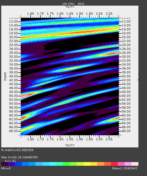
| Estimated Moho Depth: |
50.25 km |
| Estimated Crust Vp/Vs: |
1.61 |
| Assumed Crust Vp: |
6.566 km/s |
| Estimated Crust Vs: |
4.078 km/s |
| Estimated Crust Poisson's Ratio: |
0.19 |
|
| Radial Match: |
82.865364 % |
| Radial Bump: |
400 |
| Transverse Match: |
67.737526 % |
| Transverse Bump: |
400 |
| SOD ConfigId: |
790520 |
| Insert Time: |
2014-09-20 19:53:13.291 +0000 |
| GWidth: |
2.5 |
| Max Bumps: |
400 |
| Tol: |
0.001 |
|

Signal To Noise
| Channel | StoN | STA | LTA |
| UW:LRIV: :BHZ:20140906T19:28:55.234988Z | 2.3599935 | 2.2640464E-7 | 9.593443E-8 |
| UW:LRIV: :BHN:20140906T19:28:55.234988Z | 1.5269815 | 1.3186838E-7 | 8.635886E-8 |
| UW:LRIV: :BHE:20140906T19:28:55.234988Z | 1.5371826 | 1.1509049E-7 | 7.487106E-8 |
| Arrivals |
| Ps | 5.1 SECOND |
| PpPs | 18 SECOND |
| PsPs/PpSs | 23 SECOND |


