You are here: Home > Network List > GT - Global Telemetered Seismograph Network (USAF/USGS) Stations List
> Station LPAZ La Paz , Bolivia > Earthquake Result Viewer
LPAZ La Paz , Bolivia - Earthquake Result Viewer
| Earthquake location: |
South Sandwich Islands Region |
| Earthquake latitude/longitude: |
-55.4/-28.5 |
| Earthquake time(UTC): |
2014/08/24 (236) 20:21:24 GMT |
| Earthquake Depth: |
16 km |
| Earthquake Magnitude: |
5.5 MB |
| Earthquake Catalog/Contributor: |
NEIC PDE/NEIC COMCAT |
|
| Network: |
GT Global Telemetered Seismograph Network (USAF/USGS) |
| Station: |
LPAZ La Paz , Bolivia |
| Lat/Lon: |
16.17 S/68.08 W |
| Elevation: |
4817 m |
|
| Distance: |
49.5 deg |
| Az: |
306.319 deg |
| Baz: |
151.425 deg |
| Ray Param: |
0.06865859 |
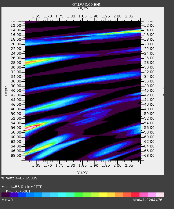
| Estimated Moho Depth: |
56.0 km |
| Estimated Crust Vp/Vs: |
1.62 |
| Assumed Crust Vp: |
6.454 km/s |
| Estimated Crust Vs: |
3.99 km/s |
| Estimated Crust Poisson's Ratio: |
0.19 |
|
| Radial Match: |
87.65309 % |
| Radial Bump: |
400 |
| Transverse Match: |
69.19086 % |
| Transverse Bump: |
400 |
| SOD ConfigId: |
790520 |
| Insert Time: |
2014-09-21 21:25:55.400 +0000 |
| GWidth: |
2.5 |
| Max Bumps: |
400 |
| Tol: |
0.001 |
|
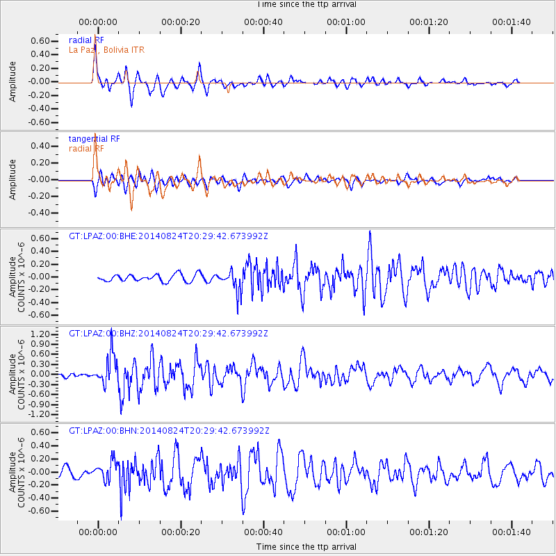
Signal To Noise
| Channel | StoN | STA | LTA |
| GT:LPAZ:00:BHZ:20140824T20:29:42.673992Z | 9.91033 | 4.5556388E-7 | 4.5968587E-8 |
| GT:LPAZ:00:BHN:20140824T20:29:42.673992Z | 2.453972 | 1.4665211E-7 | 5.976112E-8 |
| GT:LPAZ:00:BHE:20140824T20:29:42.673992Z | 3.0388885 | 1.7384633E-7 | 5.720721E-8 |
| Arrivals |
| Ps | 5.7 SECOND |
| PpPs | 21 SECOND |
| PsPs/PpSs | 27 SECOND |


