You are here: Home > Network List > CI - Caltech Regional Seismic Network Stations List
> Station BAR Barrett, Tecate, CA, USA > Earthquake Result Viewer
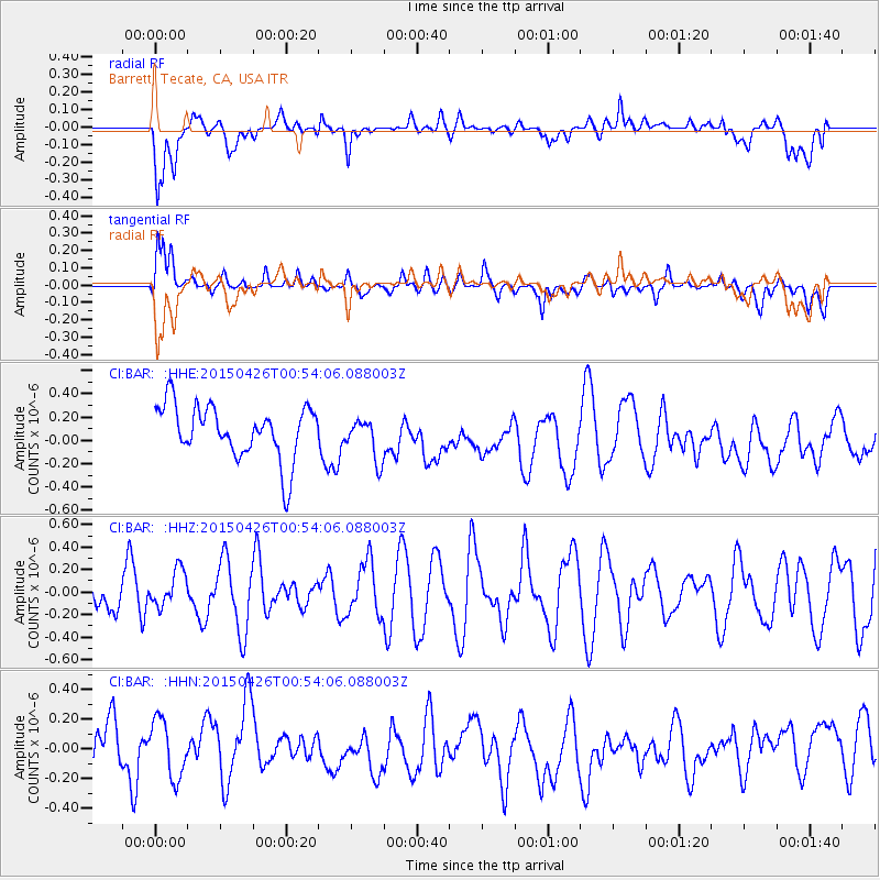
BAR Barrett, Tecate, CA, USA - Earthquake Result Viewer
*The percent match for this event was below the threshold and hence no stack was calculated.
| Earthquake location: |
South Of Mariana Islands |
| Earthquake latitude/longitude: |
12.8/143.7 |
| Earthquake time(UTC): |
2015/04/26 (116) 00:41:44 GMT |
| Earthquake Depth: |
105 km |
| Earthquake Magnitude: |
4.7 mb, 4.7 mb |
| Earthquake Catalog/Contributor: |
ISC/ISC |
|
| Network: |
CI Caltech Regional Seismic Network |
| Station: |
BAR Barrett, Tecate, CA, USA |
| Lat/Lon: |
32.68 N/116.67 W |
| Elevation: |
521 m |
|
| Distance: |
91.1 deg |
| Az: |
56.262 deg |
| Baz: |
285.883 deg |
| Ray Param: |
$rayparam |
*The percent match for this event was below the threshold and hence was not used in the summary stack. |
|
| Radial Match: |
56.977173 % |
| Radial Bump: |
400 |
| Transverse Match: |
56.14124 % |
| Transverse Bump: |
400 |
| SOD ConfigId: |
7422571 |
| Insert Time: |
2019-04-18 12:42:10.694 +0000 |
| GWidth: |
2.5 |
| Max Bumps: |
400 |
| Tol: |
0.001 |
|
Signal To Noise
| Channel | StoN | STA | LTA |
| CI:BAR: :HHZ:20150426T00:54:06.088003Z | 1.005944 | 1.6378183E-7 | 1.6281406E-7 |
| CI:BAR: :HHN:20150426T00:54:06.088003Z | 1.3998115 | 2.0084731E-7 | 1.4348169E-7 |
| CI:BAR: :HHE:20150426T00:54:06.088003Z | 0.7774841 | 1.7868521E-7 | 2.298249E-7 |
| Arrivals |
| Ps | |
| PpPs | |
| PsPs/PpSs | |


