You are here: Home > Network List > G - GEOSCOPE Stations List
> Station NOUC Port Laguerre, New Caledonia > Earthquake Result Viewer
NOUC Port Laguerre, New Caledonia - Earthquake Result Viewer
| Earthquake location: |
Southern Molucca Sea |
| Earthquake latitude/longitude: |
-0.2/125.2 |
| Earthquake time(UTC): |
2014/09/10 (253) 02:46:06 GMT |
| Earthquake Depth: |
30 km |
| Earthquake Magnitude: |
6.2 MWW, 6.1 MWB, 6.5 MI |
| Earthquake Catalog/Contributor: |
NEIC PDE/NEIC COMCAT |
|
| Network: |
G GEOSCOPE |
| Station: |
NOUC Port Laguerre, New Caledonia |
| Lat/Lon: |
22.10 S/166.30 E |
| Elevation: |
112 m |
|
| Distance: |
45.6 deg |
| Az: |
121.363 deg |
| Baz: |
292.967 deg |
| Ray Param: |
0.07111695 |
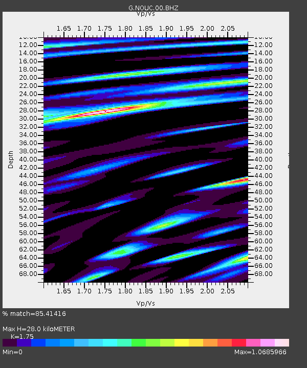
| Estimated Moho Depth: |
28.0 km |
| Estimated Crust Vp/Vs: |
1.75 |
| Assumed Crust Vp: |
5.14 km/s |
| Estimated Crust Vs: |
2.937 km/s |
| Estimated Crust Poisson's Ratio: |
0.26 |
|
| Radial Match: |
85.41416 % |
| Radial Bump: |
400 |
| Transverse Match: |
82.762245 % |
| Transverse Bump: |
366 |
| SOD ConfigId: |
790520 |
| Insert Time: |
2014-09-24 02:53:40.235 +0000 |
| GWidth: |
2.5 |
| Max Bumps: |
400 |
| Tol: |
0.001 |
|
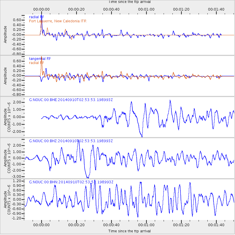
Signal To Noise
| Channel | StoN | STA | LTA |
| G:NOUC:00:BHZ:20140910T02:53:53.198993Z | 2.9064007 | 5.822321E-7 | 2.0032755E-7 |
| G:NOUC:00:BHN:20140910T02:53:53.198993Z | 1.6612777 | 2.977955E-7 | 1.7925692E-7 |
| G:NOUC:00:BHE:20140910T02:53:53.198993Z | 2.2626696 | 3.348509E-7 | 1.4798931E-7 |
| Arrivals |
| Ps | 4.3 SECOND |
| PpPs | 14 SECOND |
| PsPs/PpSs | 19 SECOND |


