You are here: Home > Network List > IC - New China Digital Seismograph Network Stations List
> Station KMI Kunming, Yunnan Province, China > Earthquake Result Viewer
KMI Kunming, Yunnan Province, China - Earthquake Result Viewer
| Earthquake location: |
Southern Molucca Sea |
| Earthquake latitude/longitude: |
-0.2/125.2 |
| Earthquake time(UTC): |
2014/09/10 (253) 02:46:06 GMT |
| Earthquake Depth: |
30 km |
| Earthquake Magnitude: |
6.2 MWW, 6.1 MWB, 6.5 MI |
| Earthquake Catalog/Contributor: |
NEIC PDE/NEIC COMCAT |
|
| Network: |
IC New China Digital Seismograph Network |
| Station: |
KMI Kunming, Yunnan Province, China |
| Lat/Lon: |
25.12 N/102.74 E |
| Elevation: |
1975 m |
|
| Distance: |
33.2 deg |
| Az: |
320.853 deg |
| Baz: |
135.858 deg |
| Ray Param: |
0.07825956 |
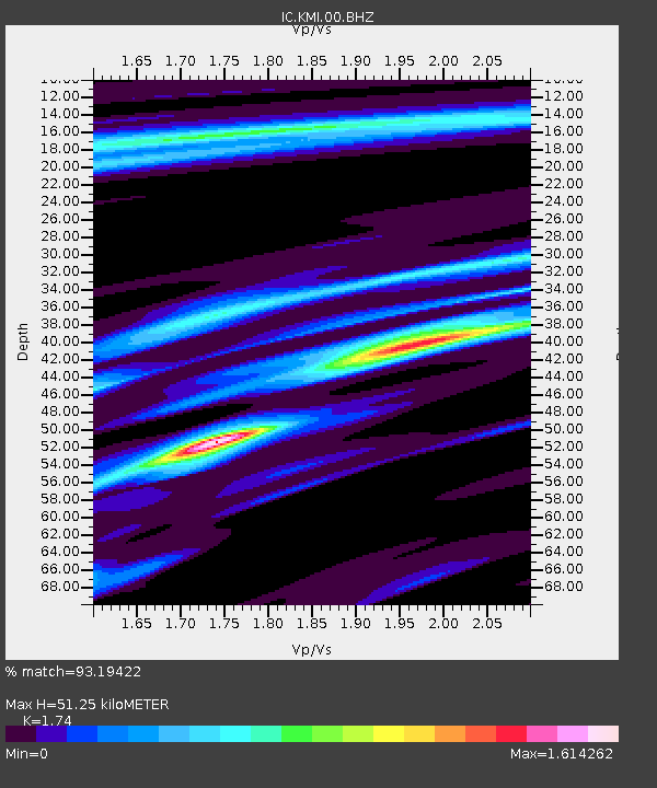
| Estimated Moho Depth: |
51.25 km |
| Estimated Crust Vp/Vs: |
1.74 |
| Assumed Crust Vp: |
6.247 km/s |
| Estimated Crust Vs: |
3.59 km/s |
| Estimated Crust Poisson's Ratio: |
0.25 |
|
| Radial Match: |
93.19422 % |
| Radial Bump: |
400 |
| Transverse Match: |
78.23015 % |
| Transverse Bump: |
400 |
| SOD ConfigId: |
790520 |
| Insert Time: |
2014-09-24 02:54:50.641 +0000 |
| GWidth: |
2.5 |
| Max Bumps: |
400 |
| Tol: |
0.001 |
|

Signal To Noise
| Channel | StoN | STA | LTA |
| IC:KMI:00:BHZ:20140910T02:52:10.318988Z | 13.981835 | 1.365727E-6 | 9.767867E-8 |
| IC:KMI:00:BH1:20140910T02:52:10.318988Z | 2.758516 | 4.7456535E-7 | 1.7203647E-7 |
| IC:KMI:00:BH2:20140910T02:52:10.318988Z | 3.2598975 | 4.1841093E-7 | 1.2835095E-7 |
| Arrivals |
| Ps | 6.5 SECOND |
| PpPs | 21 SECOND |
| PsPs/PpSs | 27 SECOND |


