You are here: Home > Network List > II - Global Seismograph Network (GSN - IRIS/IDA) Stations List
> Station ABPO Ambohimpanompo, Madagascar > Earthquake Result Viewer
ABPO Ambohimpanompo, Madagascar - Earthquake Result Viewer
| Earthquake location: |
Southern Molucca Sea |
| Earthquake latitude/longitude: |
-0.2/125.2 |
| Earthquake time(UTC): |
2014/09/10 (253) 02:46:06 GMT |
| Earthquake Depth: |
30 km |
| Earthquake Magnitude: |
6.2 MWW, 6.1 MWB, 6.5 MI |
| Earthquake Catalog/Contributor: |
NEIC PDE/NEIC COMCAT |
|
| Network: |
II Global Seismograph Network (GSN - IRIS/IDA) |
| Station: |
ABPO Ambohimpanompo, Madagascar |
| Lat/Lon: |
19.02 S/47.23 E |
| Elevation: |
1528 m |
|
| Distance: |
78.5 deg |
| Az: |
250.74 deg |
| Baz: |
86.221 deg |
| Ray Param: |
0.049531303 |
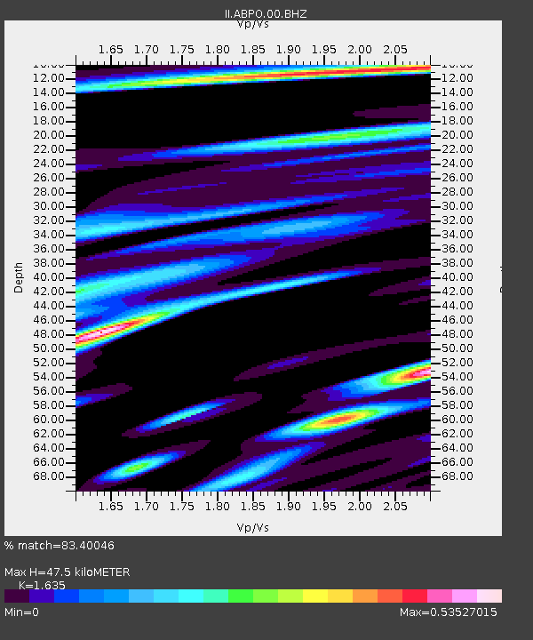
| Estimated Moho Depth: |
47.5 km |
| Estimated Crust Vp/Vs: |
1.63 |
| Assumed Crust Vp: |
6.642 km/s |
| Estimated Crust Vs: |
4.062 km/s |
| Estimated Crust Poisson's Ratio: |
0.20 |
|
| Radial Match: |
83.40046 % |
| Radial Bump: |
400 |
| Transverse Match: |
53.7606 % |
| Transverse Bump: |
400 |
| SOD ConfigId: |
790520 |
| Insert Time: |
2014-09-24 02:55:09.647 +0000 |
| GWidth: |
2.5 |
| Max Bumps: |
400 |
| Tol: |
0.001 |
|

Signal To Noise
| Channel | StoN | STA | LTA |
| II:ABPO:00:BHZ:20140910T02:57:33.76897Z | 3.4673805 | 1.2278389E-6 | 3.5411136E-7 |
| II:ABPO:00:BH1:20140910T02:57:33.76897Z | 1.7818829 | 6.439776E-7 | 3.614029E-7 |
| II:ABPO:00:BH2:20140910T02:57:33.76897Z | 2.762604 | 5.772391E-7 | 2.0894748E-7 |
| Arrivals |
| Ps | 4.7 SECOND |
| PpPs | 18 SECOND |
| PsPs/PpSs | 23 SECOND |


