You are here: Home > Network List > AK - Alaska Regional Network Stations List
> Station GAMB Gambell Broadband > Earthquake Result Viewer
GAMB Gambell Broadband - Earthquake Result Viewer
| Earthquake location: |
Nepal |
| Earthquake latitude/longitude: |
27.8/86.0 |
| Earthquake time(UTC): |
2015/04/26 (116) 07:09:08 GMT |
| Earthquake Depth: |
10 km |
| Earthquake Magnitude: |
6.7 MWP |
| Earthquake Catalog/Contributor: |
NEIC PDE/NEIC COMCAT |
|
| Network: |
AK Alaska Regional Network |
| Station: |
GAMB Gambell Broadband |
| Lat/Lon: |
63.78 N/171.70 W |
| Elevation: |
10 m |
|
| Distance: |
70.6 deg |
| Az: |
27.39 deg |
| Baz: |
293.454 deg |
| Ray Param: |
0.05485101 |
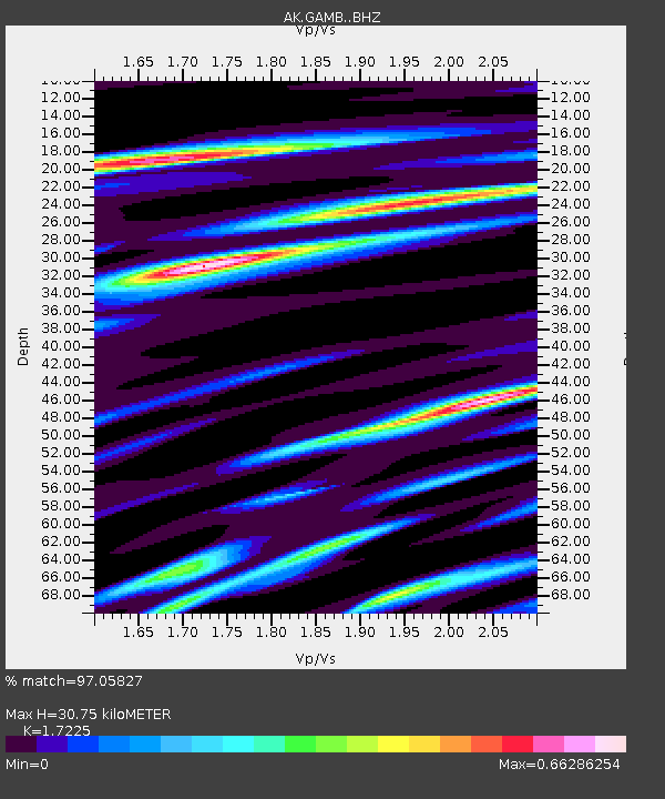
| Estimated Moho Depth: |
30.75 km |
| Estimated Crust Vp/Vs: |
1.72 |
| Assumed Crust Vp: |
6.24 km/s |
| Estimated Crust Vs: |
3.623 km/s |
| Estimated Crust Poisson's Ratio: |
0.25 |
|
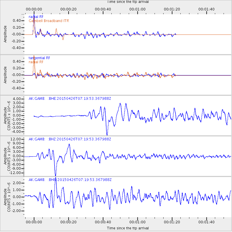
| Radial Match: |
97.05827 % |
| Radial Bump: |
259 |
| Transverse Match: |
67.047615 % |
| Transverse Bump: |
371 |
| SOD ConfigId: |
7422571 |
| Insert Time: |
2019-04-18 12:46:35.150 +0000 |
| GWidth: |
2.5 |
| Max Bumps: |
400 |
| Tol: |
0.001 |
|
Signal To Noise
| Channel | StoN | STA | LTA |
| AK:GAMB: :BHZ:20150426T07:19:53.367988Z | 15.209004 | 1.3256166E-6 | 8.715998E-8 |
| AK:GAMB: :BHN:20150426T07:19:53.367988Z | 1.4071586 | 4.0173757E-7 | 2.854956E-7 |
| AK:GAMB: :BHE:20150426T07:19:53.367988Z | 7.028162 | 6.434175E-7 | 9.1548465E-8 |
| Arrivals |
| Ps | 3.7 SECOND |
| PpPs | 13 SECOND |
| PsPs/PpSs | 17 SECOND |


