You are here: Home > Network List > AU - Australian Seismological Centre Stations List
> Station MUN Mundaring, Western Australia > Earthquake Result Viewer
MUN Mundaring, Western Australia - Earthquake Result Viewer
| Earthquake location: |
Nepal |
| Earthquake latitude/longitude: |
27.8/86.0 |
| Earthquake time(UTC): |
2015/04/26 (116) 07:09:08 GMT |
| Earthquake Depth: |
10 km |
| Earthquake Magnitude: |
6.7 MWP |
| Earthquake Catalog/Contributor: |
NEIC PDE/NEIC COMCAT |
|
| Network: |
AU Australian Seismological Centre |
| Station: |
MUN Mundaring, Western Australia |
| Lat/Lon: |
31.98 S/116.21 E |
| Elevation: |
253 m |
|
| Distance: |
66.0 deg |
| Az: |
152.079 deg |
| Baz: |
330.782 deg |
| Ray Param: |
0.057872776 |
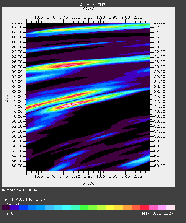
| Estimated Moho Depth: |
43.0 km |
| Estimated Crust Vp/Vs: |
1.78 |
| Assumed Crust Vp: |
6.419 km/s |
| Estimated Crust Vs: |
3.606 km/s |
| Estimated Crust Poisson's Ratio: |
0.27 |
|
| Radial Match: |
92.9684 % |
| Radial Bump: |
309 |
| Transverse Match: |
77.15989 % |
| Transverse Bump: |
400 |
| SOD ConfigId: |
7422571 |
| Insert Time: |
2019-04-18 12:47:30.794 +0000 |
| GWidth: |
2.5 |
| Max Bumps: |
400 |
| Tol: |
0.001 |
|

Signal To Noise
| Channel | StoN | STA | LTA |
| AU:MUN: :BHZ:20150426T07:19:24.068977Z | 2.9838002 | 9.99622E-7 | 3.350164E-7 |
| AU:MUN: :BHN:20150426T07:19:24.068977Z | 1.8369026 | 4.5482477E-7 | 2.476042E-7 |
| AU:MUN: :BHE:20150426T07:19:24.068977Z | 0.65951115 | 1.7981777E-7 | 2.7265312E-7 |
| Arrivals |
| Ps | 5.4 SECOND |
| PpPs | 18 SECOND |
| PsPs/PpSs | 23 SECOND |


