You are here: Home > Network List > AV - Alaska Volcano Observatory Stations List
> Station AMKA Regional Station, Amchitka Island, Alaska > Earthquake Result Viewer
AMKA Regional Station, Amchitka Island, Alaska - Earthquake Result Viewer

| Earthquake location: |
Nepal |
| Earthquake latitude/longitude: |
27.8/86.0 |
| Earthquake time(UTC): |
2015/04/26 (116) 07:09:08 GMT |
| Earthquake Depth: |
10 km |
| Earthquake Magnitude: |
6.7 MWP |
| Earthquake Catalog/Contributor: |
NEIC PDE/NEIC COMCAT |
|
| Network: |
AV Alaska Volcano Observatory |
| Station: |
AMKA Regional Station, Amchitka Island, Alaska |
| Lat/Lon: |
51.38 N/179.30 E |
| Elevation: |
116 m |
|
| Distance: |
70.8 deg |
| Az: |
41.5 deg |
| Baz: |
290.507 deg |
| Ray Param: |
0.054757103 |
| Estimated Moho Depth: |
36.75 km |
| Estimated Crust Vp/Vs: |
1.71 |
| Assumed Crust Vp: |
6.183 km/s |
| Estimated Crust Vs: |
3.61 km/s |
| Estimated Crust Poisson's Ratio: |
0.24 |
|
| Radial Match: |
86.45544 % |
| Radial Bump: |
400 |
| Transverse Match: |
86.30832 % |
| Transverse Bump: |
400 |
| SOD ConfigId: |
7422571 |
| Insert Time: |
2019-04-18 12:47:38.726 +0000 |
| GWidth: |
2.5 |
| Max Bumps: |
400 |
| Tol: |
0.001 |
|
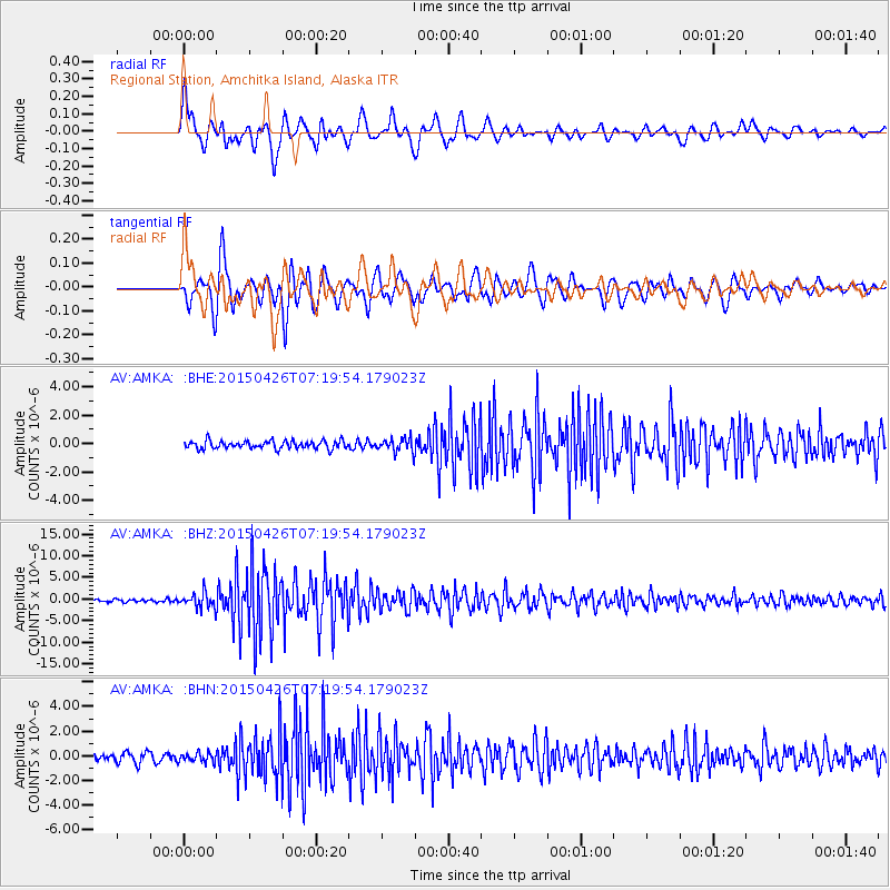
Signal To Noise
| Channel | StoN | STA | LTA |
| AV:AMKA: :BHZ:20150426T07:19:54.179023Z | 5.9950676 | 1.7775357E-6 | 2.9649968E-7 |
| AV:AMKA: :BHN:20150426T07:19:54.179023Z | 1.2577859 | 3.8030626E-7 | 3.0236168E-7 |
| AV:AMKA: :BHE:20150426T07:19:54.179023Z | 1.76245 | 4.9135224E-7 | 2.7878932E-7 |
| Arrivals |
| Ps | 4.4 SECOND |
| PpPs | 16 SECOND |
| PsPs/PpSs | 20 SECOND |


