You are here: Home > Network List > JP - Japan Meteorological Agency Seismic Network Stations List
> Station JMM Miyagi Marumori > Earthquake Result Viewer
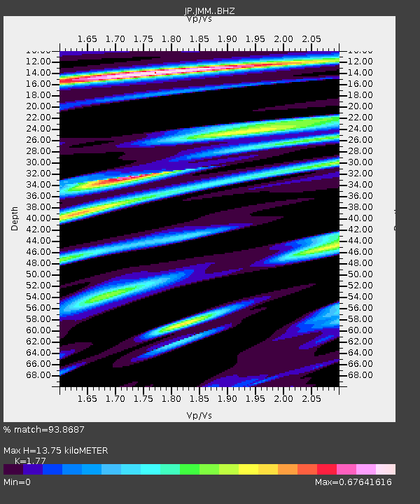
JMM Miyagi Marumori - Earthquake Result Viewer
| Earthquake location: |
Nepal |
| Earthquake latitude/longitude: |
27.8/86.0 |
| Earthquake time(UTC): |
2015/04/26 (116) 07:09:08 GMT |
| Earthquake Depth: |
10 km |
| Earthquake Magnitude: |
6.7 MWP |
| Earthquake Catalog/Contributor: |
NEIC PDE/NEIC COMCAT |
|
| Network: |
JP Japan Meteorological Agency Seismic Network |
| Station: |
JMM Miyagi Marumori |
| Lat/Lon: |
37.87 N/140.79 E |
| Elevation: |
100 m |
|
| Distance: |
46.6 deg |
| Az: |
62.968 deg |
| Baz: |
274.348 deg |
| Ray Param: |
0.07056583 |
| Estimated Moho Depth: |
13.75 km |
| Estimated Crust Vp/Vs: |
1.77 |
| Assumed Crust Vp: |
6.24 km/s |
| Estimated Crust Vs: |
3.525 km/s |
| Estimated Crust Poisson's Ratio: |
0.27 |
|
| Radial Match: |
93.8687 % |
| Radial Bump: |
364 |
| Transverse Match: |
90.91382 % |
| Transverse Bump: |
400 |
| SOD ConfigId: |
7422571 |
| Insert Time: |
2019-04-18 12:49:08.839 +0000 |
| GWidth: |
2.5 |
| Max Bumps: |
400 |
| Tol: |
0.001 |
|

Signal To Noise
| Channel | StoN | STA | LTA |
| JP:JMM: :BHZ:20150426T07:17:05.850013Z | 9.983906 | 2.6249338E-6 | 2.6291653E-7 |
| JP:JMM: :BHN:20150426T07:17:05.850013Z | 1.1903268 | 2.4464094E-7 | 2.0552419E-7 |
| JP:JMM: :BHE:20150426T07:17:05.850013Z | 6.1298223 | 1.2042522E-6 | 1.9645792E-7 |
| Arrivals |
| Ps | 1.8 SECOND |
| PpPs | 5.8 SECOND |
| PsPs/PpSs | 7.6 SECOND |


