You are here: Home > Network List > JP - Japan Meteorological Agency Seismic Network Stations List
> Station JTU Tsushima Kamiagata > Earthquake Result Viewer
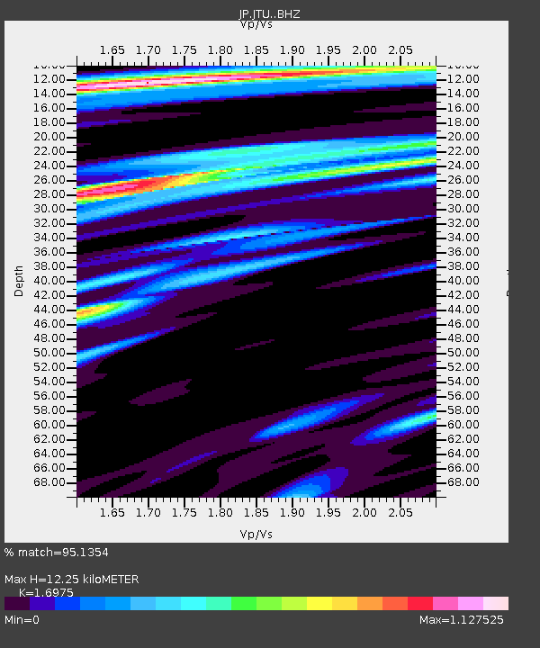
JTU Tsushima Kamiagata - Earthquake Result Viewer
| Earthquake location: |
Nepal |
| Earthquake latitude/longitude: |
27.8/86.0 |
| Earthquake time(UTC): |
2015/04/26 (116) 07:09:08 GMT |
| Earthquake Depth: |
10 km |
| Earthquake Magnitude: |
6.7 MWP |
| Earthquake Catalog/Contributor: |
NEIC PDE/NEIC COMCAT |
|
| Network: |
JP Japan Meteorological Agency Seismic Network |
| Station: |
JTU Tsushima Kamiagata |
| Lat/Lon: |
34.53 N/129.40 E |
| Elevation: |
70 m |
|
| Distance: |
37.5 deg |
| Az: |
68.662 deg |
| Baz: |
271.874 deg |
| Ray Param: |
0.07608182 |
| Estimated Moho Depth: |
12.25 km |
| Estimated Crust Vp/Vs: |
1.70 |
| Assumed Crust Vp: |
6.472 km/s |
| Estimated Crust Vs: |
3.813 km/s |
| Estimated Crust Poisson's Ratio: |
0.23 |
|
| Radial Match: |
95.1354 % |
| Radial Bump: |
360 |
| Transverse Match: |
88.32313 % |
| Transverse Bump: |
398 |
| SOD ConfigId: |
7422571 |
| Insert Time: |
2019-04-18 12:49:16.070 +0000 |
| GWidth: |
2.5 |
| Max Bumps: |
400 |
| Tol: |
0.001 |
|

Signal To Noise
| Channel | StoN | STA | LTA |
| JP:JTU: :BHZ:20150426T07:15:52.299995Z | 18.55822 | 2.3677674E-6 | 1.275859E-7 |
| JP:JTU: :BHN:20150426T07:15:52.299995Z | 1.0544096 | 1.3333216E-7 | 1.2645197E-7 |
| JP:JTU: :BHE:20150426T07:15:52.299995Z | 10.173268 | 1.1808859E-6 | 1.1607733E-7 |
| Arrivals |
| Ps | 1.4 SECOND |
| PpPs | 4.7 SECOND |
| PsPs/PpSs | 6.1 SECOND |


