You are here: Home > Network List > TA - USArray Transportable Network (new EarthScope stations) Stations List
> Station TCOL CIGO, UAF Yankovich Road, Fairbanks, AK, USA > Earthquake Result Viewer
TCOL CIGO, UAF Yankovich Road, Fairbanks, AK, USA - Earthquake Result Viewer
| Earthquake location: |
Nepal |
| Earthquake latitude/longitude: |
27.8/86.0 |
| Earthquake time(UTC): |
2015/04/26 (116) 07:09:08 GMT |
| Earthquake Depth: |
10 km |
| Earthquake Magnitude: |
6.7 MWP |
| Earthquake Catalog/Contributor: |
NEIC PDE/NEIC COMCAT |
|
| Network: |
TA USArray Transportable Network (new EarthScope stations) |
| Station: |
TCOL CIGO, UAF Yankovich Road, Fairbanks, AK, USA |
| Lat/Lon: |
64.87 N/147.86 W |
| Elevation: |
178 m |
|
| Distance: |
78.7 deg |
| Az: |
20.581 deg |
| Baz: |
313.163 deg |
| Ray Param: |
0.0494753 |
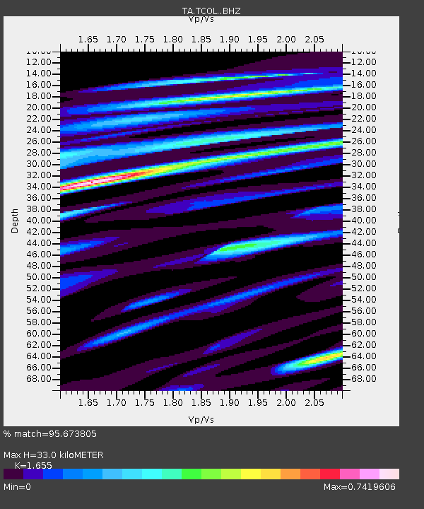
| Estimated Moho Depth: |
33.0 km |
| Estimated Crust Vp/Vs: |
1.65 |
| Assumed Crust Vp: |
6.566 km/s |
| Estimated Crust Vs: |
3.967 km/s |
| Estimated Crust Poisson's Ratio: |
0.21 |
|
| Radial Match: |
95.673805 % |
| Radial Bump: |
400 |
| Transverse Match: |
88.06029 % |
| Transverse Bump: |
400 |
| SOD ConfigId: |
7422571 |
| Insert Time: |
2019-04-18 12:50:28.075 +0000 |
| GWidth: |
2.5 |
| Max Bumps: |
400 |
| Tol: |
0.001 |
|

Signal To Noise
| Channel | StoN | STA | LTA |
| TA:TCOL: :BHZ:20150426T07:20:39.899971Z | 21.014849 | 1.8766185E-6 | 8.929965E-8 |
| TA:TCOL: :BHN:20150426T07:20:39.899971Z | 4.2491336 | 5.0152977E-7 | 1.1803107E-7 |
| TA:TCOL: :BHE:20150426T07:20:39.899971Z | 6.872084 | 7.3512876E-7 | 1.069732E-7 |
| Arrivals |
| Ps | 3.4 SECOND |
| PpPs | 13 SECOND |
| PsPs/PpSs | 16 SECOND |


