You are here: Home > Network List > YQ13 - Study of Extension and Magmatism in Malawi and Tanzania Stations List
> Station GAWA Igawa,Tanzania > Earthquake Result Viewer
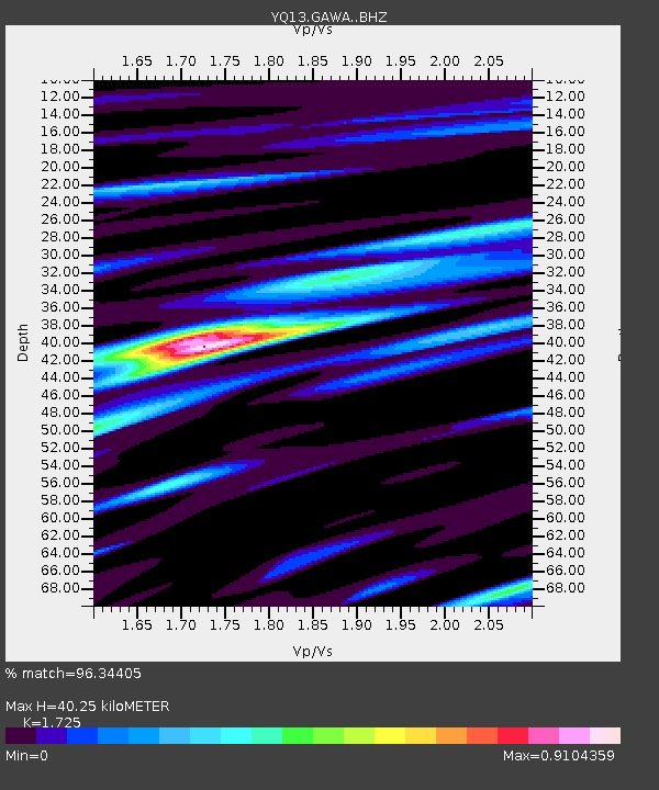
GAWA Igawa,Tanzania - Earthquake Result Viewer
| Earthquake location: |
Nepal |
| Earthquake latitude/longitude: |
27.8/86.0 |
| Earthquake time(UTC): |
2015/04/26 (116) 07:09:08 GMT |
| Earthquake Depth: |
10 km |
| Earthquake Magnitude: |
6.7 MWP |
| Earthquake Catalog/Contributor: |
NEIC PDE/NEIC COMCAT |
|
| Network: |
YQ Study of Extension and Magmatism in Malawi and Tanzania |
| Station: |
GAWA Igawa,Tanzania |
| Lat/Lon: |
8.76 S/34.39 E |
| Elevation: |
1127 m |
|
| Distance: |
61.7 deg |
| Az: |
241.588 deg |
| Baz: |
52.026 deg |
| Ray Param: |
0.06069815 |
| Estimated Moho Depth: |
40.25 km |
| Estimated Crust Vp/Vs: |
1.73 |
| Assumed Crust Vp: |
6.576 km/s |
| Estimated Crust Vs: |
3.812 km/s |
| Estimated Crust Poisson's Ratio: |
0.25 |
|
| Radial Match: |
96.34405 % |
| Radial Bump: |
337 |
| Transverse Match: |
86.14054 % |
| Transverse Bump: |
400 |
| SOD ConfigId: |
7422571 |
| Insert Time: |
2019-04-18 12:51:21.677 +0000 |
| GWidth: |
2.5 |
| Max Bumps: |
400 |
| Tol: |
0.001 |
|

Signal To Noise
| Channel | StoN | STA | LTA |
| YQ:GAWA: :BHZ:20150426T07:18:55.78498Z | 16.214998 | 8.570782E-7 | 5.285713E-8 |
| YQ:GAWA: :BHN:20150426T07:18:55.78498Z | 4.4966426 | 1.8686582E-7 | 4.1556742E-8 |
| YQ:GAWA: :BHE:20150426T07:18:55.78498Z | 10.496783 | 3.659969E-7 | 3.486753E-8 |
| Arrivals |
| Ps | 4.7 SECOND |
| PpPs | 16 SECOND |
| PsPs/PpSs | 21 SECOND |


