You are here: Home > Network List > TA - USArray Transportable Network (new EarthScope stations) Stations List
> Station A04D Lummi Island, WA, USA > Earthquake Result Viewer
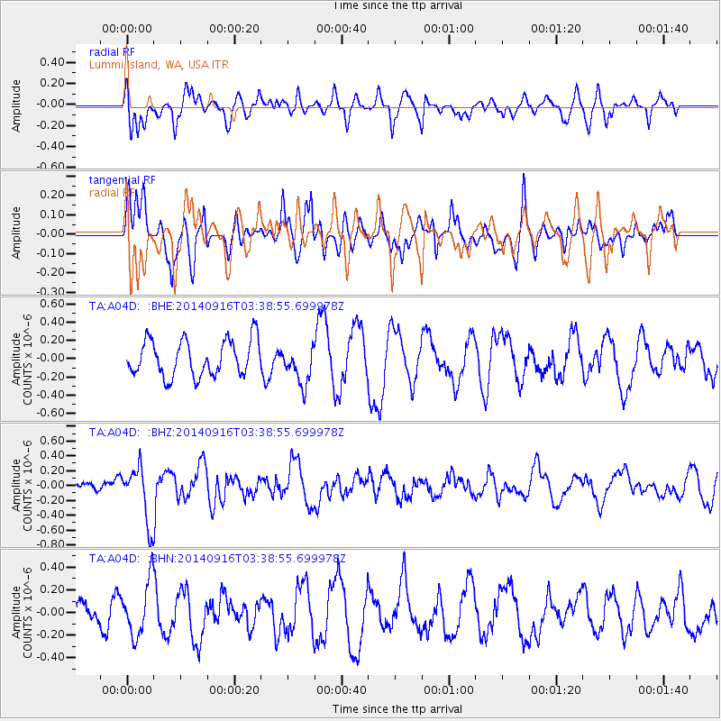
A04D Lummi Island, WA, USA - Earthquake Result Viewer
*The percent match for this event was below the threshold and hence no stack was calculated.
| Earthquake location: |
Eastern Honshu, Japan |
| Earthquake latitude/longitude: |
36.1/139.9 |
| Earthquake time(UTC): |
2014/09/16 (259) 03:28:31 GMT |
| Earthquake Depth: |
54 km |
| Earthquake Magnitude: |
5.6 MB |
| Earthquake Catalog/Contributor: |
NEIC PDE/NEIC COMCAT |
|
| Network: |
TA USArray Transportable Network (new EarthScope stations) |
| Station: |
A04D Lummi Island, WA, USA |
| Lat/Lon: |
48.72 N/122.71 W |
| Elevation: |
13 m |
|
| Distance: |
68.3 deg |
| Az: |
44.977 deg |
| Baz: |
300.141 deg |
| Ray Param: |
$rayparam |
*The percent match for this event was below the threshold and hence was not used in the summary stack. |
|
| Radial Match: |
66.30404 % |
| Radial Bump: |
400 |
| Transverse Match: |
56.731915 % |
| Transverse Bump: |
400 |
| SOD ConfigId: |
795072 |
| Insert Time: |
2014-09-30 04:29:40.613 +0000 |
| GWidth: |
2.5 |
| Max Bumps: |
400 |
| Tol: |
0.001 |
|
Signal To Noise
| Channel | StoN | STA | LTA |
| TA:A04D: :BHZ:20140916T03:38:55.699978Z | 2.3644614 | 3.8200676E-7 | 1.6156184E-7 |
| TA:A04D: :BHN:20140916T03:38:55.699978Z | 2.2434657 | 2.4201898E-7 | 1.07877284E-7 |
| TA:A04D: :BHE:20140916T03:38:55.699978Z | 1.0786647 | 2.1177767E-7 | 1.9633319E-7 |
| Arrivals |
| Ps | |
| PpPs | |
| PsPs/PpSs | |


