You are here: Home > Network List > TA - USArray Transportable Network (new EarthScope stations) Stations List
> Station D58A Chemin du LacGrosbois, Trois-Rives, QC, CAN > Earthquake Result Viewer
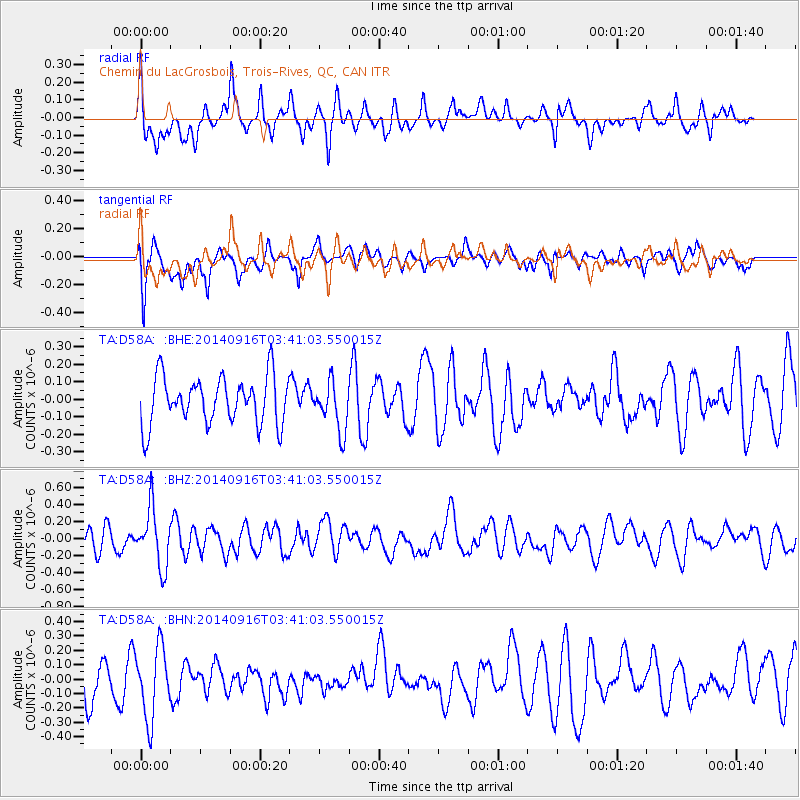
D58A Chemin du LacGrosbois, Trois-Rives, QC, CAN - Earthquake Result Viewer
*The percent match for this event was below the threshold and hence no stack was calculated.
| Earthquake location: |
Eastern Honshu, Japan |
| Earthquake latitude/longitude: |
36.1/139.9 |
| Earthquake time(UTC): |
2014/09/16 (259) 03:28:31 GMT |
| Earthquake Depth: |
54 km |
| Earthquake Magnitude: |
5.6 MB |
| Earthquake Catalog/Contributor: |
NEIC PDE/NEIC COMCAT |
|
| Network: |
TA USArray Transportable Network (new EarthScope stations) |
| Station: |
D58A Chemin du LacGrosbois, Trois-Rives, QC, CAN |
| Lat/Lon: |
47.10 N/72.88 W |
| Elevation: |
398 m |
|
| Distance: |
92.2 deg |
| Az: |
21.712 deg |
| Baz: |
333.978 deg |
| Ray Param: |
$rayparam |
*The percent match for this event was below the threshold and hence was not used in the summary stack. |
|
| Radial Match: |
58.382362 % |
| Radial Bump: |
400 |
| Transverse Match: |
65.13548 % |
| Transverse Bump: |
400 |
| SOD ConfigId: |
795072 |
| Insert Time: |
2014-09-30 04:33:30.271 +0000 |
| GWidth: |
2.5 |
| Max Bumps: |
400 |
| Tol: |
0.001 |
|
Signal To Noise
| Channel | StoN | STA | LTA |
| TA:D58A: :BHZ:20140916T03:41:03.550015Z | 2.3211787 | 3.3995258E-7 | 1.4645688E-7 |
| TA:D58A: :BHN:20140916T03:41:03.550015Z | 1.808553 | 2.463157E-7 | 1.361949E-7 |
| TA:D58A: :BHE:20140916T03:41:03.550015Z | 1.0165919 | 1.388162E-7 | 1.3655057E-7 |
| Arrivals |
| Ps | |
| PpPs | |
| PsPs/PpSs | |


