You are here: Home > Network List > TA - USArray Transportable Network (new EarthScope stations) Stations List
> Station E62A Clayton Lake, ME, USA > Earthquake Result Viewer
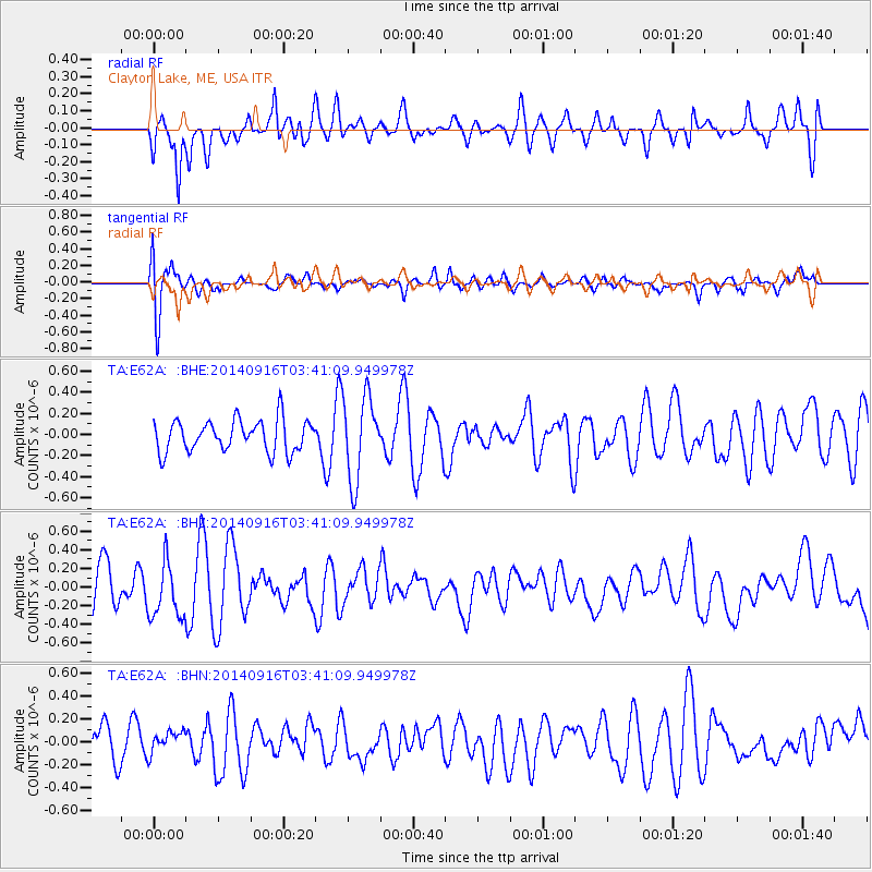
E62A Clayton Lake, ME, USA - Earthquake Result Viewer
*The percent match for this event was below the threshold and hence no stack was calculated.
| Earthquake location: |
Eastern Honshu, Japan |
| Earthquake latitude/longitude: |
36.1/139.9 |
| Earthquake time(UTC): |
2014/09/16 (259) 03:28:31 GMT |
| Earthquake Depth: |
54 km |
| Earthquake Magnitude: |
5.6 MB |
| Earthquake Catalog/Contributor: |
NEIC PDE/NEIC COMCAT |
|
| Network: |
TA USArray Transportable Network (new EarthScope stations) |
| Station: |
E62A Clayton Lake, ME, USA |
| Lat/Lon: |
46.62 N/69.52 W |
| Elevation: |
356 m |
|
| Distance: |
93.6 deg |
| Az: |
19.815 deg |
| Baz: |
336.516 deg |
| Ray Param: |
$rayparam |
*The percent match for this event was below the threshold and hence was not used in the summary stack. |
|
| Radial Match: |
57.497158 % |
| Radial Bump: |
400 |
| Transverse Match: |
76.98683 % |
| Transverse Bump: |
400 |
| SOD ConfigId: |
795072 |
| Insert Time: |
2014-09-30 04:34:01.097 +0000 |
| GWidth: |
2.5 |
| Max Bumps: |
400 |
| Tol: |
0.001 |
|
Signal To Noise
| Channel | StoN | STA | LTA |
| TA:E62A: :BHZ:20140916T03:41:09.949978Z | 1.5441755 | 2.9843966E-7 | 1.9326795E-7 |
| TA:E62A: :BHN:20140916T03:41:09.949978Z | 0.7109424 | 9.622418E-8 | 1.3534736E-7 |
| TA:E62A: :BHE:20140916T03:41:09.949978Z | 2.6417396 | 3.962043E-7 | 1.4997856E-7 |
| Arrivals |
| Ps | |
| PpPs | |
| PsPs/PpSs | |


