You are here: Home > Network List > TA - USArray Transportable Network (new EarthScope stations) Stations List
> Station Z41A Richland Creek Farm, El Dorado, AR, USA > Earthquake Result Viewer
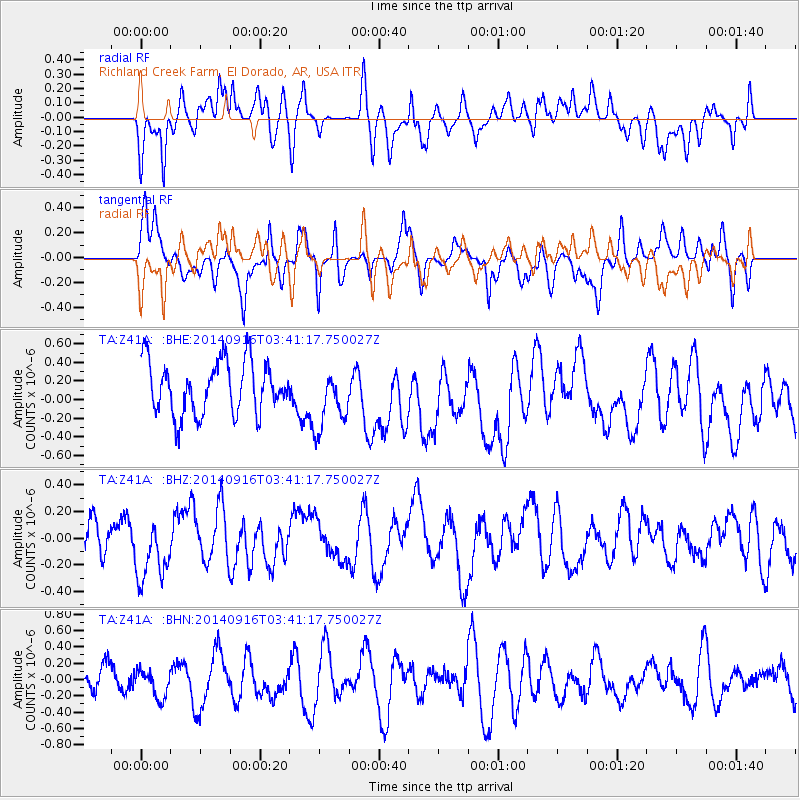
Z41A Richland Creek Farm, El Dorado, AR, USA - Earthquake Result Viewer
*The percent match for this event was below the threshold and hence no stack was calculated.
| Earthquake location: |
Eastern Honshu, Japan |
| Earthquake latitude/longitude: |
36.1/139.9 |
| Earthquake time(UTC): |
2014/09/16 (259) 03:28:31 GMT |
| Earthquake Depth: |
54 km |
| Earthquake Magnitude: |
5.6 MB |
| Earthquake Catalog/Contributor: |
NEIC PDE/NEIC COMCAT |
|
| Network: |
TA USArray Transportable Network (new EarthScope stations) |
| Station: |
Z41A Richland Creek Farm, El Dorado, AR, USA |
| Lat/Lon: |
33.26 N/92.80 W |
| Elevation: |
62 m |
|
| Distance: |
95.3 deg |
| Az: |
42.001 deg |
| Baz: |
319.679 deg |
| Ray Param: |
$rayparam |
*The percent match for this event was below the threshold and hence was not used in the summary stack. |
|
| Radial Match: |
40.85094 % |
| Radial Bump: |
400 |
| Transverse Match: |
49.500122 % |
| Transverse Bump: |
400 |
| SOD ConfigId: |
795072 |
| Insert Time: |
2014-09-30 04:38:55.088 +0000 |
| GWidth: |
2.5 |
| Max Bumps: |
400 |
| Tol: |
0.001 |
|
Signal To Noise
| Channel | StoN | STA | LTA |
| TA:Z41A: :BHZ:20140916T03:41:17.750027Z | 1.919361 | 2.3881253E-7 | 1.2442294E-7 |
| TA:Z41A: :BHN:20140916T03:41:17.750027Z | 0.74142474 | 1.7220022E-7 | 2.3225581E-7 |
| TA:Z41A: :BHE:20140916T03:41:17.750027Z | 1.1757625 | 3.3088608E-7 | 2.8142253E-7 |
| Arrivals |
| Ps | |
| PpPs | |
| PsPs/PpSs | |


