You are here: Home > Network List > US - United States National Seismic Network Stations List
> Station ERPA Erie, Pennsylvania, USA > Earthquake Result Viewer
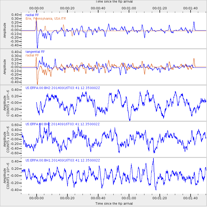
ERPA Erie, Pennsylvania, USA - Earthquake Result Viewer
*The percent match for this event was below the threshold and hence no stack was calculated.
| Earthquake location: |
Eastern Honshu, Japan |
| Earthquake latitude/longitude: |
36.1/139.9 |
| Earthquake time(UTC): |
2014/09/16 (259) 03:28:31 GMT |
| Earthquake Depth: |
54 km |
| Earthquake Magnitude: |
5.6 MB |
| Earthquake Catalog/Contributor: |
NEIC PDE/NEIC COMCAT |
|
| Network: |
US United States National Seismic Network |
| Station: |
ERPA Erie, Pennsylvania, USA |
| Lat/Lon: |
42.12 N/79.99 W |
| Elevation: |
306 m |
|
| Distance: |
94.1 deg |
| Az: |
28.561 deg |
| Baz: |
328.624 deg |
| Ray Param: |
$rayparam |
*The percent match for this event was below the threshold and hence was not used in the summary stack. |
|
| Radial Match: |
72.53859 % |
| Radial Bump: |
400 |
| Transverse Match: |
76.23002 % |
| Transverse Bump: |
400 |
| SOD ConfigId: |
795072 |
| Insert Time: |
2014-09-30 04:40:20.613 +0000 |
| GWidth: |
2.5 |
| Max Bumps: |
400 |
| Tol: |
0.001 |
|
Signal To Noise
| Channel | StoN | STA | LTA |
| US:ERPA:00:BHZ:20140916T03:41:12.350002Z | 0.9880173 | 2.3445929E-7 | 2.3730283E-7 |
| US:ERPA:00:BH1:20140916T03:41:12.350002Z | 0.9263591 | 1.3586708E-7 | 1.4666783E-7 |
| US:ERPA:00:BH2:20140916T03:41:12.350002Z | 1.4525757 | 2.5360293E-7 | 1.7458845E-7 |
| Arrivals |
| Ps | |
| PpPs | |
| PsPs/PpSs | |


