You are here: Home > Network List > TA - USArray Transportable Network (new EarthScope stations) Stations List
> Station O03E Paynes Creek, CA, USA > Earthquake Result Viewer
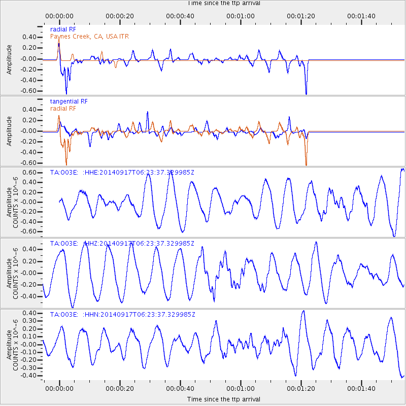
O03E Paynes Creek, CA, USA - Earthquake Result Viewer
*The percent match for this event was below the threshold and hence no stack was calculated.
| Earthquake location: |
Vanuatu Islands |
| Earthquake latitude/longitude: |
-16.0/168.0 |
| Earthquake time(UTC): |
2014/09/17 (260) 06:11:49 GMT |
| Earthquake Depth: |
181 km |
| Earthquake Magnitude: |
5.6 MB |
| Earthquake Catalog/Contributor: |
NEIC PDE/NEIC COMCAT |
|
| Network: |
TA USArray Transportable Network (new EarthScope stations) |
| Station: |
O03E Paynes Creek, CA, USA |
| Lat/Lon: |
40.29 N/121.80 W |
| Elevation: |
967 m |
|
| Distance: |
85.9 deg |
| Az: |
46.19 deg |
| Baz: |
245.119 deg |
| Ray Param: |
$rayparam |
*The percent match for this event was below the threshold and hence was not used in the summary stack. |
|
| Radial Match: |
86.817726 % |
| Radial Bump: |
400 |
| Transverse Match: |
63.25663 % |
| Transverse Bump: |
367 |
| SOD ConfigId: |
795072 |
| Insert Time: |
2014-10-01 06:45:39.974 +0000 |
| GWidth: |
2.5 |
| Max Bumps: |
400 |
| Tol: |
0.001 |
|
Signal To Noise
| Channel | StoN | STA | LTA |
| TA:O03E: :HHZ:20140917T06:23:37.329985Z | 2.2731009 | 3.7187957E-7 | 1.6360012E-7 |
| TA:O03E: :HHN:20140917T06:23:37.329985Z | 0.95561546 | 1.8408831E-7 | 1.9263847E-7 |
| TA:O03E: :HHE:20140917T06:23:37.329985Z | 2.8990562 | 4.1535793E-7 | 1.4327351E-7 |
| Arrivals |
| Ps | |
| PpPs | |
| PsPs/PpSs | |


