You are here: Home > Network List > TA - USArray Transportable Network (new EarthScope stations) Stations List
> Station R11A Troy Canyon, Currant, NV, USA > Earthquake Result Viewer
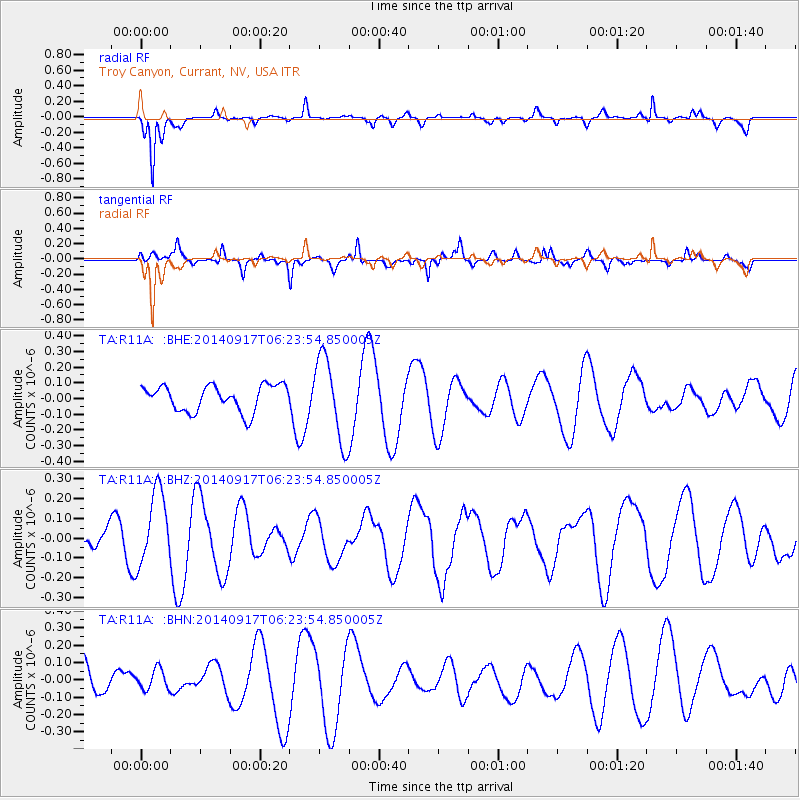
R11A Troy Canyon, Currant, NV, USA - Earthquake Result Viewer
*The percent match for this event was below the threshold and hence no stack was calculated.
| Earthquake location: |
Vanuatu Islands |
| Earthquake latitude/longitude: |
-16.0/168.0 |
| Earthquake time(UTC): |
2014/09/17 (260) 06:11:49 GMT |
| Earthquake Depth: |
181 km |
| Earthquake Magnitude: |
5.6 MB |
| Earthquake Catalog/Contributor: |
NEIC PDE/NEIC COMCAT |
|
| Network: |
TA USArray Transportable Network (new EarthScope stations) |
| Station: |
R11A Troy Canyon, Currant, NV, USA |
| Lat/Lon: |
38.35 N/115.59 W |
| Elevation: |
1756 m |
|
| Distance: |
89.6 deg |
| Az: |
49.853 deg |
| Baz: |
249.191 deg |
| Ray Param: |
$rayparam |
*The percent match for this event was below the threshold and hence was not used in the summary stack. |
|
| Radial Match: |
66.612816 % |
| Radial Bump: |
283 |
| Transverse Match: |
69.822815 % |
| Transverse Bump: |
396 |
| SOD ConfigId: |
795072 |
| Insert Time: |
2014-10-01 06:45:48.896 +0000 |
| GWidth: |
2.5 |
| Max Bumps: |
400 |
| Tol: |
0.001 |
|
Signal To Noise
| Channel | StoN | STA | LTA |
| TA:R11A: :BHZ:20140917T06:23:54.850005Z | 1.7982055 | 1.8733944E-7 | 1.0418133E-7 |
| TA:R11A: :BHN:20140917T06:23:54.850005Z | 0.81661195 | 6.808255E-8 | 8.337197E-8 |
| TA:R11A: :BHE:20140917T06:23:54.850005Z | 3.226119 | 2.6639887E-7 | 8.257565E-8 |
| Arrivals |
| Ps | |
| PpPs | |
| PsPs/PpSs | |


