You are here: Home > Network List > AK - Alaska Regional Network Stations List
> Station ISLE Juniper Island, AK, USA > Earthquake Result Viewer
ISLE Juniper Island, AK, USA - Earthquake Result Viewer
| Earthquake location: |
Mariana Islands |
| Earthquake latitude/longitude: |
13.8/144.4 |
| Earthquake time(UTC): |
2014/09/17 (260) 06:14:46 GMT |
| Earthquake Depth: |
137 km |
| Earthquake Magnitude: |
6.7 MWC, 7.1 MI |
| Earthquake Catalog/Contributor: |
NEIC PDE/NEIC COMCAT |
|
| Network: |
AK Alaska Regional Network |
| Station: |
ISLE Juniper Island, AK, USA |
| Lat/Lon: |
60.60 N/142.34 W |
| Elevation: |
1485 m |
|
| Distance: |
69.9 deg |
| Az: |
30.206 deg |
| Baz: |
262.238 deg |
| Ray Param: |
0.054973625 |
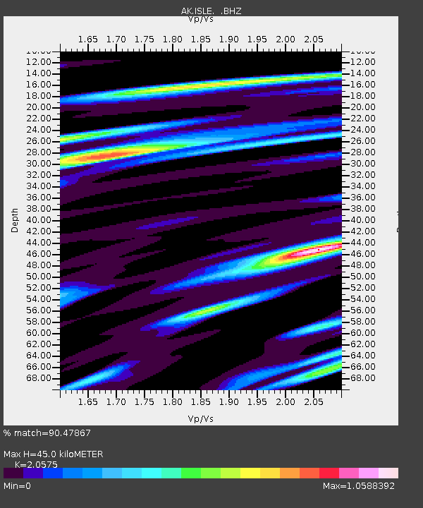
| Estimated Moho Depth: |
45.0 km |
| Estimated Crust Vp/Vs: |
2.06 |
| Assumed Crust Vp: |
6.566 km/s |
| Estimated Crust Vs: |
3.191 km/s |
| Estimated Crust Poisson's Ratio: |
0.35 |
|
| Radial Match: |
90.47867 % |
| Radial Bump: |
400 |
| Transverse Match: |
84.15656 % |
| Transverse Bump: |
400 |
| SOD ConfigId: |
795072 |
| Insert Time: |
2014-10-01 07:02:55.993 +0000 |
| GWidth: |
2.5 |
| Max Bumps: |
400 |
| Tol: |
0.001 |
|

Signal To Noise
| Channel | StoN | STA | LTA |
| AK:ISLE: :BHZ:20140917T06:25:11.528003Z | 49.897003 | 7.028576E-6 | 1.4086167E-7 |
| AK:ISLE: :BHN:20140917T06:25:11.528003Z | 10.2266245 | 1.9080687E-6 | 1.8657853E-7 |
| AK:ISLE: :BHE:20140917T06:25:11.528003Z | 27.48254 | 3.2285666E-6 | 1.17477015E-7 |
| Arrivals |
| Ps | 7.5 SECOND |
| PpPs | 20 SECOND |
| PsPs/PpSs | 28 SECOND |


