You are here: Home > Network List > AK - Alaska Regional Network Stations List
> Station SAMH Samovar Hills, AK, USA > Earthquake Result Viewer
SAMH Samovar Hills, AK, USA - Earthquake Result Viewer
| Earthquake location: |
Mariana Islands |
| Earthquake latitude/longitude: |
13.8/144.4 |
| Earthquake time(UTC): |
2014/09/17 (260) 06:14:46 GMT |
| Earthquake Depth: |
137 km |
| Earthquake Magnitude: |
6.7 MWC, 7.1 MI |
| Earthquake Catalog/Contributor: |
NEIC PDE/NEIC COMCAT |
|
| Network: |
AK Alaska Regional Network |
| Station: |
SAMH Samovar Hills, AK, USA |
| Lat/Lon: |
60.13 N/140.78 W |
| Elevation: |
1140 m |
|
| Distance: |
70.6 deg |
| Az: |
30.806 deg |
| Baz: |
263.793 deg |
| Ray Param: |
0.054507174 |
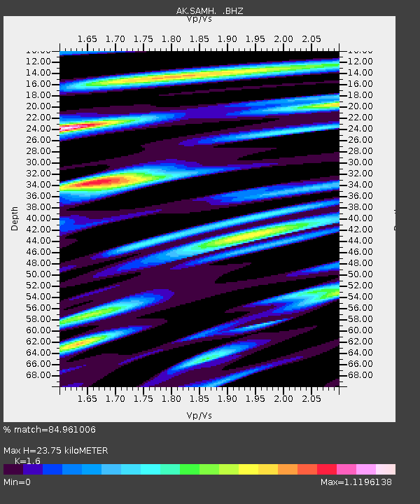
| Estimated Moho Depth: |
23.75 km |
| Estimated Crust Vp/Vs: |
1.60 |
| Assumed Crust Vp: |
6.566 km/s |
| Estimated Crust Vs: |
4.104 km/s |
| Estimated Crust Poisson's Ratio: |
0.18 |
|
| Radial Match: |
84.961006 % |
| Radial Bump: |
400 |
| Transverse Match: |
81.172356 % |
| Transverse Bump: |
400 |
| SOD ConfigId: |
795072 |
| Insert Time: |
2014-10-01 07:03:59.840 +0000 |
| GWidth: |
2.5 |
| Max Bumps: |
400 |
| Tol: |
0.001 |
|

Signal To Noise
| Channel | StoN | STA | LTA |
| AK:SAMH: :BHZ:20140917T06:25:15.827991Z | 41.183743 | 9.077593E-6 | 2.204169E-7 |
| AK:SAMH: :BHN:20140917T06:25:15.827991Z | 6.4898024 | 1.307759E-6 | 2.0150983E-7 |
| AK:SAMH: :BHE:20140917T06:25:15.827991Z | 9.406261 | 3.5720768E-6 | 3.7975522E-7 |
| Arrivals |
| Ps | 2.3 SECOND |
| PpPs | 9.0 SECOND |
| PsPs/PpSs | 11 SECOND |


