You are here: Home > Network List > AK - Alaska Regional Network Stations List
> Station SLK Skilak Lake, AK, USA > Earthquake Result Viewer
SLK Skilak Lake, AK, USA - Earthquake Result Viewer
| Earthquake location: |
Mariana Islands |
| Earthquake latitude/longitude: |
13.8/144.4 |
| Earthquake time(UTC): |
2014/09/17 (260) 06:14:46 GMT |
| Earthquake Depth: |
137 km |
| Earthquake Magnitude: |
6.7 MWC, 7.1 MI |
| Earthquake Catalog/Contributor: |
NEIC PDE/NEIC COMCAT |
|
| Network: |
AK Alaska Regional Network |
| Station: |
SLK Skilak Lake, AK, USA |
| Lat/Lon: |
60.51 N/150.22 W |
| Elevation: |
655 m |
|
| Distance: |
66.1 deg |
| Az: |
29.477 deg |
| Baz: |
255.109 deg |
| Ray Param: |
0.057476133 |
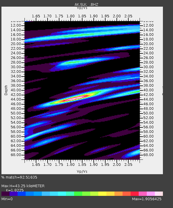
| Estimated Moho Depth: |
43.25 km |
| Estimated Crust Vp/Vs: |
1.82 |
| Assumed Crust Vp: |
6.302 km/s |
| Estimated Crust Vs: |
3.458 km/s |
| Estimated Crust Poisson's Ratio: |
0.28 |
|
| Radial Match: |
92.51635 % |
| Radial Bump: |
398 |
| Transverse Match: |
83.83363 % |
| Transverse Bump: |
400 |
| SOD ConfigId: |
795072 |
| Insert Time: |
2014-10-01 07:04:12.614 +0000 |
| GWidth: |
2.5 |
| Max Bumps: |
400 |
| Tol: |
0.001 |
|

Signal To Noise
| Channel | StoN | STA | LTA |
| AK:SLK: :BHZ:20140917T06:24:47.647998Z | 62.329792 | 8.02581E-6 | 1.2876362E-7 |
| AK:SLK: :BHN:20140917T06:24:47.647998Z | 6.86919 | 1.0799091E-6 | 1.5721055E-7 |
| AK:SLK: :BHE:20140917T06:24:47.647998Z | 40.82964 | 4.9735645E-6 | 1.218126E-7 |
| Arrivals |
| Ps | 5.9 SECOND |
| PpPs | 19 SECOND |
| PsPs/PpSs | 25 SECOND |


