You are here: Home > Network List > AU - Australian Seismological Centre Stations List
> Station ARMA Armidale, New South Wales > Earthquake Result Viewer
ARMA Armidale, New South Wales - Earthquake Result Viewer
| Earthquake location: |
Mariana Islands |
| Earthquake latitude/longitude: |
13.8/144.4 |
| Earthquake time(UTC): |
2014/09/17 (260) 06:14:46 GMT |
| Earthquake Depth: |
137 km |
| Earthquake Magnitude: |
6.7 MWC, 7.1 MI |
| Earthquake Catalog/Contributor: |
NEIC PDE/NEIC COMCAT |
|
| Network: |
AU Australian Seismological Centre |
| Station: |
ARMA Armidale, New South Wales |
| Lat/Lon: |
30.42 S/151.63 E |
| Elevation: |
1112 m |
|
| Distance: |
44.5 deg |
| Az: |
171.069 deg |
| Baz: |
349.943 deg |
| Ray Param: |
0.071406335 |
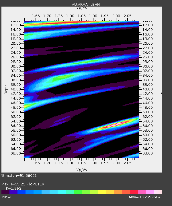
| Estimated Moho Depth: |
55.25 km |
| Estimated Crust Vp/Vs: |
2.00 |
| Assumed Crust Vp: |
6.577 km/s |
| Estimated Crust Vs: |
3.297 km/s |
| Estimated Crust Poisson's Ratio: |
0.33 |
|
| Radial Match: |
91.66021 % |
| Radial Bump: |
341 |
| Transverse Match: |
74.40505 % |
| Transverse Bump: |
400 |
| SOD ConfigId: |
795072 |
| Insert Time: |
2014-10-01 07:06:03.756 +0000 |
| GWidth: |
2.5 |
| Max Bumps: |
400 |
| Tol: |
0.001 |
|

Signal To Noise
| Channel | StoN | STA | LTA |
| AU:ARMA: :BHZ:20140917T06:22:13.244006Z | 3.9885404 | 1.9460488E-6 | 4.8791003E-7 |
| AU:ARMA: :BHN:20140917T06:22:13.244006Z | 2.9788384 | 9.914354E-7 | 3.3282618E-7 |
| AU:ARMA: :BHE:20140917T06:22:13.244006Z | 1.4654772 | 5.125118E-7 | 3.497235E-7 |
| Arrivals |
| Ps | 8.9 SECOND |
| PpPs | 24 SECOND |
| PsPs/PpSs | 33 SECOND |


