You are here: Home > Network List > AU - Australian Seismological Centre Stations List
> Station PSAD2 Pilbara Seismic Array Element D2 > Earthquake Result Viewer
PSAD2 Pilbara Seismic Array Element D2 - Earthquake Result Viewer
| Earthquake location: |
Mariana Islands |
| Earthquake latitude/longitude: |
13.8/144.4 |
| Earthquake time(UTC): |
2014/09/17 (260) 06:14:46 GMT |
| Earthquake Depth: |
137 km |
| Earthquake Magnitude: |
6.7 MWC, 7.1 MI |
| Earthquake Catalog/Contributor: |
NEIC PDE/NEIC COMCAT |
|
| Network: |
AU Australian Seismological Centre |
| Station: |
PSAD2 Pilbara Seismic Array Element D2 |
| Lat/Lon: |
21.62 S/119.96 E |
| Elevation: |
366 m |
|
| Distance: |
42.6 deg |
| Az: |
214.691 deg |
| Baz: |
36.466 deg |
| Ray Param: |
0.07260836 |
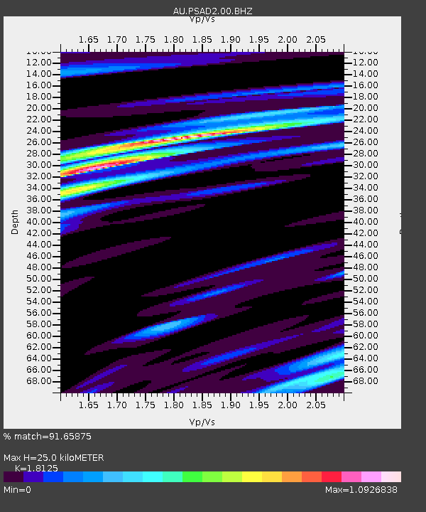
| Estimated Moho Depth: |
25.0 km |
| Estimated Crust Vp/Vs: |
1.81 |
| Assumed Crust Vp: |
6.464 km/s |
| Estimated Crust Vs: |
3.566 km/s |
| Estimated Crust Poisson's Ratio: |
0.28 |
|
| Radial Match: |
91.65875 % |
| Radial Bump: |
397 |
| Transverse Match: |
75.054695 % |
| Transverse Bump: |
400 |
| SOD ConfigId: |
795072 |
| Insert Time: |
2014-10-01 07:11:33.782 +0000 |
| GWidth: |
2.5 |
| Max Bumps: |
400 |
| Tol: |
0.001 |
|

Signal To Noise
| Channel | StoN | STA | LTA |
| AU:PSAD2:00:BHZ:20140917T06:21:57.969012Z | 16.291868 | 7.498717E-6 | 4.602736E-7 |
| AU:PSAD2:00:BH1:20140917T06:21:57.969012Z | 10.207853 | 3.498264E-6 | 3.427032E-7 |
| AU:PSAD2:00:BH2:20140917T06:21:57.969012Z | 16.460957 | 3.0971191E-6 | 1.881494E-7 |
| Arrivals |
| Ps | 3.4 SECOND |
| PpPs | 10 SECOND |
| PsPs/PpSs | 14 SECOND |


