You are here: Home > Network List > AV - Alaska Volcano Observatory Stations List
> Station MAPS Pakushin Southeast, Makushin Volcano, Alaska > Earthquake Result Viewer
MAPS Pakushin Southeast, Makushin Volcano, Alaska - Earthquake Result Viewer
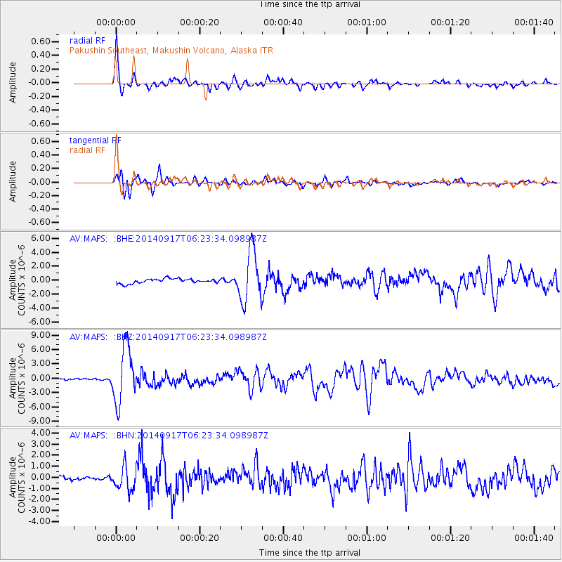
| Earthquake location: |
Mariana Islands |
| Earthquake latitude/longitude: |
13.8/144.4 |
| Earthquake time(UTC): |
2014/09/17 (260) 06:14:46 GMT |
| Earthquake Depth: |
137 km |
| Earthquake Magnitude: |
6.7 MWC, 7.1 MI |
| Earthquake Catalog/Contributor: |
NEIC PDE/NEIC COMCAT |
|
| Network: |
AV Alaska Volcano Observatory |
| Station: |
MAPS Pakushin Southeast, Makushin Volcano, Alaska |
| Lat/Lon: |
53.81 N/166.94 W |
| Elevation: |
333 m |
|
| Distance: |
55.2 deg |
| Az: |
32.844 deg |
| Baz: |
242.697 deg |
| Ray Param: |
0.06451682 |
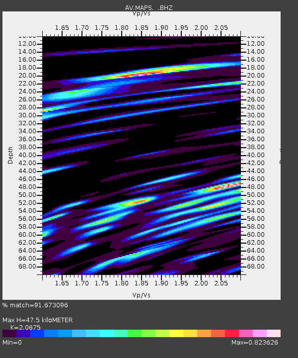
| Estimated Moho Depth: |
47.5 km |
| Estimated Crust Vp/Vs: |
2.07 |
| Assumed Crust Vp: |
3.943 km/s |
| Estimated Crust Vs: |
1.907 km/s |
| Estimated Crust Poisson's Ratio: |
0.35 |
|
| Radial Match: |
91.673096 % |
| Radial Bump: |
400 |
| Transverse Match: |
86.77477 % |
| Transverse Bump: |
400 |
| SOD ConfigId: |
795072 |
| Insert Time: |
2014-10-01 07:13:00.143 +0000 |
| GWidth: |
2.5 |
| Max Bumps: |
400 |
| Tol: |
0.001 |
|
Signal To Noise
| Channel | StoN | STA | LTA |
| AV:MAPS: :BHZ:20140917T06:23:34.098987Z | 33.902573 | 5.882517E-6 | 1.735124E-7 |
| AV:MAPS: :BHN:20140917T06:23:34.098987Z | 8.115144 | 1.0978331E-6 | 1.3528202E-7 |
| AV:MAPS: :BHE:20140917T06:23:34.098987Z | 11.432138 | 3.76145E-6 | 3.2902418E-7 |
| Arrivals |
| Ps | 13 SECOND |
| PpPs | 36 SECOND |
| PsPs/PpSs | 49 SECOND |


