You are here: Home > Network List > AV - Alaska Volcano Observatory Stations List
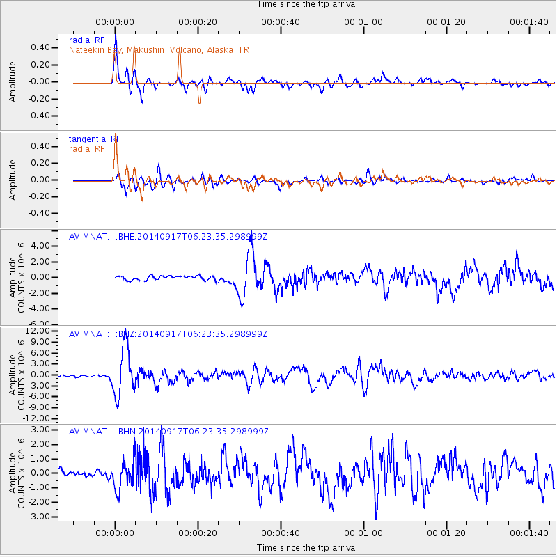
> Station MNAT Nateekin Bay, Makushin Volcano, Alaska > Earthquake Result Viewer
MNAT Nateekin Bay, Makushin Volcano, Alaska - Earthquake Result Viewer
| Earthquake location: |
Mariana Islands |
| Earthquake latitude/longitude: |
13.8/144.4 |
| Earthquake time(UTC): |
2014/09/17 (260) 06:14:46 GMT |
| Earthquake Depth: |
137 km |
| Earthquake Magnitude: |
6.7 MWC, 7.1 MI |
| Earthquake Catalog/Contributor: |
NEIC PDE/NEIC COMCAT |
|
| Network: |
AV Alaska Volcano Observatory |
| Station: |
MNAT Nateekin Bay, Makushin Volcano, Alaska |
| Lat/Lon: |
53.88 N/166.69 W |
| Elevation: |
390 m |
|
| Distance: |
55.4 deg |
| Az: |
32.847 deg |
| Baz: |
242.904 deg |
| Ray Param: |
0.06440798 |
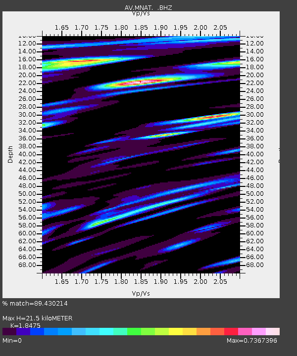
| Estimated Moho Depth: |
21.5 km |
| Estimated Crust Vp/Vs: |
1.85 |
| Assumed Crust Vp: |
3.943 km/s |
| Estimated Crust Vs: |
2.134 km/s |
| Estimated Crust Poisson's Ratio: |
0.29 |
|
| Radial Match: |
89.430214 % |
| Radial Bump: |
400 |
| Transverse Match: |
76.54668 % |
| Transverse Bump: |
400 |
| SOD ConfigId: |
795072 |
| Insert Time: |
2014-10-01 07:13:06.013 +0000 |
| GWidth: |
2.5 |
| Max Bumps: |
400 |
| Tol: |
0.001 |
|
Signal To Noise
| Channel | StoN | STA | LTA |
| AV:MNAT: :BHZ:20140917T06:23:35.298999Z | 41.551743 | 6.7023025E-6 | 1.6130016E-7 |
| AV:MNAT: :BHN:20140917T06:23:35.298999Z | 4.5224557 | 1.0550966E-6 | 2.3330169E-7 |
| AV:MNAT: :BHE:20140917T06:23:35.298999Z | 10.853772 | 2.896117E-6 | 2.6683043E-7 |
| Arrivals |
| Ps | 4.7 SECOND |
| PpPs | 15 SECOND |
| PsPs/PpSs | 20 SECOND |


