You are here: Home > Network List > TA - USArray Transportable Network (new EarthScope stations) Stations List
> Station A21K Barrow, AK, USA > Earthquake Result Viewer
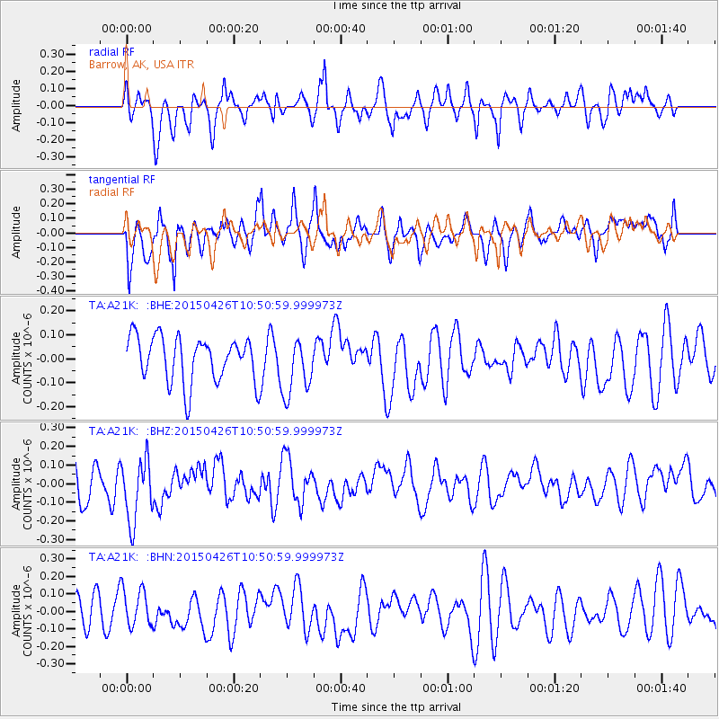
A21K Barrow, AK, USA - Earthquake Result Viewer
*The percent match for this event was below the threshold and hence no stack was calculated.
| Earthquake location: |
Sumba Region, Indonesia |
| Earthquake latitude/longitude: |
-10.6/120.4 |
| Earthquake time(UTC): |
2015/04/26 (116) 10:37:59 GMT |
| Earthquake Depth: |
31 km |
| Earthquake Magnitude: |
5.1 mb, 5.2 mb, 4.3 MS |
| Earthquake Catalog/Contributor: |
ISC/ISC |
|
| Network: |
TA USArray Transportable Network (new EarthScope stations) |
| Station: |
A21K Barrow, AK, USA |
| Lat/Lon: |
71.32 N/156.62 W |
| Elevation: |
577 m |
|
| Distance: |
97.7 deg |
| Az: |
18.823 deg |
| Baz: |
259.934 deg |
| Ray Param: |
$rayparam |
*The percent match for this event was below the threshold and hence was not used in the summary stack. |
|
| Radial Match: |
53.58702 % |
| Radial Bump: |
368 |
| Transverse Match: |
59.47542 % |
| Transverse Bump: |
400 |
| SOD ConfigId: |
7422571 |
| Insert Time: |
2019-04-18 13:03:04.387 +0000 |
| GWidth: |
2.5 |
| Max Bumps: |
400 |
| Tol: |
0.001 |
|
Signal To Noise
| Channel | StoN | STA | LTA |
| TA:A21K: :BHZ:20150426T10:50:59.999973Z | 2.1374042 | 1.7076418E-7 | 7.989326E-8 |
| TA:A21K: :BHN:20150426T10:50:59.999973Z | 1.2424552 | 1.06191614E-7 | 8.546917E-8 |
| TA:A21K: :BHE:20150426T10:50:59.999973Z | 1.2670138 | 1.2057278E-7 | 9.516296E-8 |
| Arrivals |
| Ps | |
| PpPs | |
| PsPs/PpSs | |


