You are here: Home > Network List > CC - Cascade Chain Volcano Monitoring Stations List
> Station JRO Johnston Ridge Observatory > Earthquake Result Viewer
JRO Johnston Ridge Observatory - Earthquake Result Viewer
| Earthquake location: |
Mariana Islands |
| Earthquake latitude/longitude: |
13.8/144.4 |
| Earthquake time(UTC): |
2014/09/17 (260) 06:14:46 GMT |
| Earthquake Depth: |
137 km |
| Earthquake Magnitude: |
6.7 MWC, 7.1 MI |
| Earthquake Catalog/Contributor: |
NEIC PDE/NEIC COMCAT |
|
| Network: |
CC Cascade Chain Volcano Monitoring |
| Station: |
JRO Johnston Ridge Observatory |
| Lat/Lon: |
46.28 N/122.22 W |
| Elevation: |
1280 m |
|
| Distance: |
82.5 deg |
| Az: |
44.296 deg |
| Baz: |
281.946 deg |
| Ray Param: |
0.046527453 |
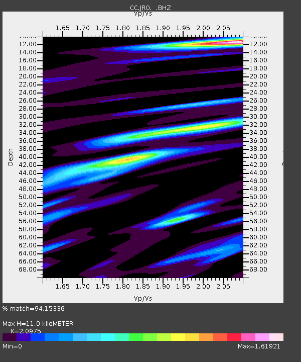
| Estimated Moho Depth: |
11.0 km |
| Estimated Crust Vp/Vs: |
2.10 |
| Assumed Crust Vp: |
6.566 km/s |
| Estimated Crust Vs: |
3.13 km/s |
| Estimated Crust Poisson's Ratio: |
0.35 |
|
| Radial Match: |
94.15336 % |
| Radial Bump: |
400 |
| Transverse Match: |
87.996864 % |
| Transverse Bump: |
400 |
| SOD ConfigId: |
795072 |
| Insert Time: |
2014-10-01 07:16:08.350 +0000 |
| GWidth: |
2.5 |
| Max Bumps: |
400 |
| Tol: |
0.001 |
|

Signal To Noise
| Channel | StoN | STA | LTA |
| CC:JRO: :BHZ:20140917T06:26:22.480029Z | 70.479095 | 1.3794642E-5 | 1.9572673E-7 |
| CC:JRO: :BHN:20140917T06:26:22.480029Z | 13.148295 | 1.773657E-6 | 1.3489635E-7 |
| CC:JRO: :BHE:20140917T06:26:22.480029Z | 32.582684 | 6.8449763E-6 | 2.100802E-7 |
| Arrivals |
| Ps | 1.9 SECOND |
| PpPs | 5.1 SECOND |
| PsPs/PpSs | 7.0 SECOND |


