You are here: Home > Network List > CC - Cascade Chain Volcano Monitoring Stations List
> Station OBSR Observation Rock, Mt. Rainier, WA > Earthquake Result Viewer
OBSR Observation Rock, Mt. Rainier, WA - Earthquake Result Viewer
| Earthquake location: |
Mariana Islands |
| Earthquake latitude/longitude: |
13.8/144.4 |
| Earthquake time(UTC): |
2014/09/17 (260) 06:14:46 GMT |
| Earthquake Depth: |
137 km |
| Earthquake Magnitude: |
6.7 MWC, 7.1 MI |
| Earthquake Catalog/Contributor: |
NEIC PDE/NEIC COMCAT |
|
| Network: |
CC Cascade Chain Volcano Monitoring |
| Station: |
OBSR Observation Rock, Mt. Rainier, WA |
| Lat/Lon: |
46.90 N/121.82 W |
| Elevation: |
2382 m |
|
| Distance: |
82.6 deg |
| Az: |
43.622 deg |
| Baz: |
282.15 deg |
| Ray Param: |
0.04643016 |
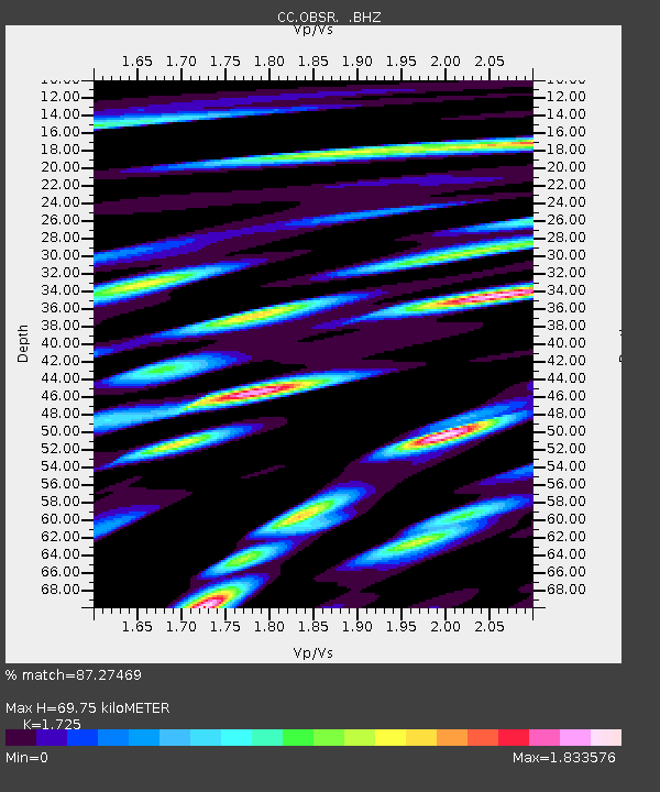
| Estimated Moho Depth: |
69.75 km |
| Estimated Crust Vp/Vs: |
1.73 |
| Assumed Crust Vp: |
6.597 km/s |
| Estimated Crust Vs: |
3.825 km/s |
| Estimated Crust Poisson's Ratio: |
0.25 |
|
| Radial Match: |
87.27469 % |
| Radial Bump: |
400 |
| Transverse Match: |
77.61207 % |
| Transverse Bump: |
400 |
| SOD ConfigId: |
795072 |
| Insert Time: |
2014-10-01 07:16:13.878 +0000 |
| GWidth: |
2.5 |
| Max Bumps: |
400 |
| Tol: |
0.001 |
|

Signal To Noise
| Channel | StoN | STA | LTA |
| CC:OBSR: :BHZ:20140917T06:26:23.22002Z | 63.591984 | 1.10779865E-5 | 1.7420413E-7 |
| CC:OBSR: :BHN:20140917T06:26:23.22002Z | 15.061494 | 3.2978116E-6 | 2.1895649E-7 |
| CC:OBSR: :BHE:20140917T06:26:23.22002Z | 29.051657 | 5.8190376E-6 | 2.0029968E-7 |
| Arrivals |
| Ps | 7.9 SECOND |
| PpPs | 28 SECOND |
| PsPs/PpSs | 36 SECOND |


