You are here: Home > Network List > CC - Cascade Chain Volcano Monitoring Stations List
> Station STD Studebaker Ridge, Mount St Helens, WA > Earthquake Result Viewer
STD Studebaker Ridge, Mount St Helens, WA - Earthquake Result Viewer
| Earthquake location: |
Mariana Islands |
| Earthquake latitude/longitude: |
13.8/144.4 |
| Earthquake time(UTC): |
2014/09/17 (260) 06:14:46 GMT |
| Earthquake Depth: |
137 km |
| Earthquake Magnitude: |
6.7 MWC, 7.1 MI |
| Earthquake Catalog/Contributor: |
NEIC PDE/NEIC COMCAT |
|
| Network: |
CC Cascade Chain Volcano Monitoring |
| Station: |
STD Studebaker Ridge, Mount St Helens, WA |
| Lat/Lon: |
46.24 N/122.22 W |
| Elevation: |
1268 m |
|
| Distance: |
82.5 deg |
| Az: |
44.334 deg |
| Baz: |
281.946 deg |
| Ray Param: |
0.046524987 |
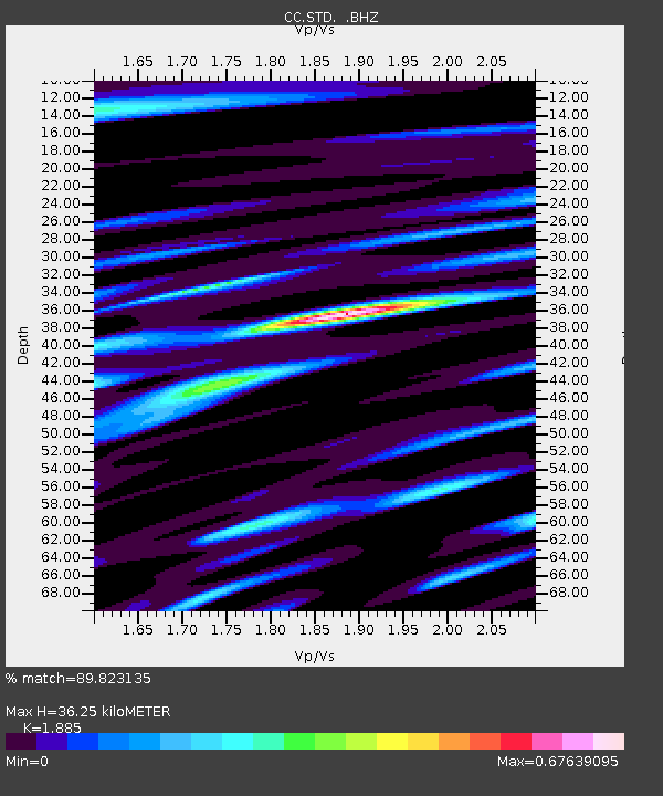
| Estimated Moho Depth: |
36.25 km |
| Estimated Crust Vp/Vs: |
1.88 |
| Assumed Crust Vp: |
6.566 km/s |
| Estimated Crust Vs: |
3.483 km/s |
| Estimated Crust Poisson's Ratio: |
0.30 |
|
| Radial Match: |
89.823135 % |
| Radial Bump: |
400 |
| Transverse Match: |
50.372005 % |
| Transverse Bump: |
400 |
| SOD ConfigId: |
795072 |
| Insert Time: |
2014-10-01 07:16:19.093 +0000 |
| GWidth: |
2.5 |
| Max Bumps: |
400 |
| Tol: |
0.001 |
|

Signal To Noise
| Channel | StoN | STA | LTA |
| CC:STD: :BHZ:20140917T06:26:22.499988Z | 74.448006 | 1.2857833E-5 | 1.727089E-7 |
| CC:STD: :BHN:20140917T06:26:22.499988Z | 1.974684 | 1.0246123E-6 | 5.1887406E-7 |
| CC:STD: :BHE:20140917T06:26:22.499988Z | 11.893722 | 2.849272E-6 | 2.3956102E-7 |
| Arrivals |
| Ps | 5.0 SECOND |
| PpPs | 16 SECOND |
| PsPs/PpSs | 21 SECOND |


