You are here: Home > Network List > CC - Cascade Chain Volcano Monitoring Stations List
> Station SWNB Southwest, Newberry, OR > Earthquake Result Viewer
SWNB Southwest, Newberry, OR - Earthquake Result Viewer
| Earthquake location: |
Mariana Islands |
| Earthquake latitude/longitude: |
13.8/144.4 |
| Earthquake time(UTC): |
2014/09/17 (260) 06:14:46 GMT |
| Earthquake Depth: |
137 km |
| Earthquake Magnitude: |
6.7 MWC, 7.1 MI |
| Earthquake Catalog/Contributor: |
NEIC PDE/NEIC COMCAT |
|
| Network: |
CC Cascade Chain Volcano Monitoring |
| Station: |
SWNB Southwest, Newberry, OR |
| Lat/Lon: |
43.67 N/121.36 W |
| Elevation: |
1569 m |
|
| Distance: |
83.7 deg |
| Az: |
46.724 deg |
| Baz: |
282.846 deg |
| Ray Param: |
0.04571686 |
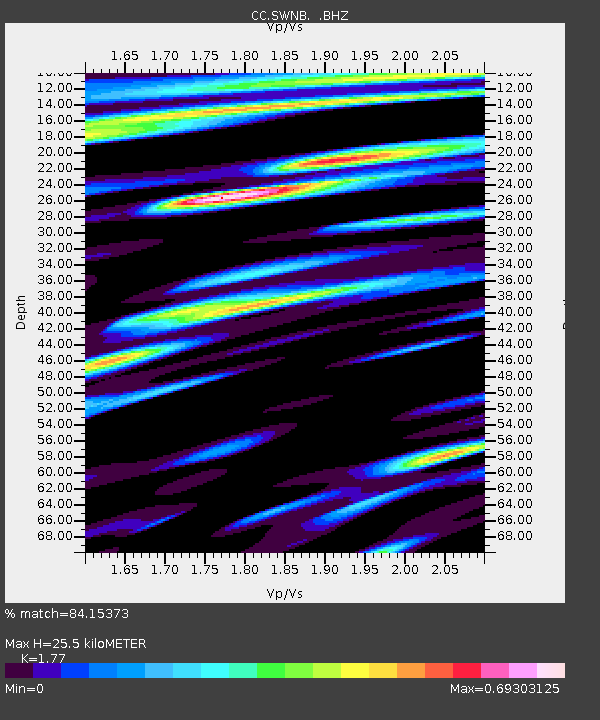
| Estimated Moho Depth: |
25.5 km |
| Estimated Crust Vp/Vs: |
1.77 |
| Assumed Crust Vp: |
6.597 km/s |
| Estimated Crust Vs: |
3.727 km/s |
| Estimated Crust Poisson's Ratio: |
0.27 |
|
| Radial Match: |
84.15373 % |
| Radial Bump: |
400 |
| Transverse Match: |
82.692 % |
| Transverse Bump: |
400 |
| SOD ConfigId: |
795072 |
| Insert Time: |
2014-10-01 07:16:24.126 +0000 |
| GWidth: |
2.5 |
| Max Bumps: |
400 |
| Tol: |
0.001 |
|

Signal To Noise
| Channel | StoN | STA | LTA |
| CC:SWNB: :BHZ:20140917T06:26:28.400012Z | 93.385056 | 1.2436172E-5 | 1.331709E-7 |
| CC:SWNB: :BHN:20140917T06:26:28.400012Z | 4.9510994 | 1.1298042E-6 | 2.281926E-7 |
| CC:SWNB: :BHE:20140917T06:26:28.400012Z | 16.933264 | 3.3708645E-6 | 1.9906763E-7 |
| Arrivals |
| Ps | 3.1 SECOND |
| PpPs | 10 SECOND |
| PsPs/PpSs | 13 SECOND |


