You are here: Home > Network List > CC - Cascade Chain Volcano Monitoring Stations List
> Station TCBU Trout Creek Butte at 3-Sisters, OR > Earthquake Result Viewer
TCBU Trout Creek Butte at 3-Sisters, OR - Earthquake Result Viewer
| Earthquake location: |
Mariana Islands |
| Earthquake latitude/longitude: |
13.8/144.4 |
| Earthquake time(UTC): |
2014/09/17 (260) 06:14:46 GMT |
| Earthquake Depth: |
137 km |
| Earthquake Magnitude: |
6.7 MWC, 7.1 MI |
| Earthquake Catalog/Contributor: |
NEIC PDE/NEIC COMCAT |
|
| Network: |
CC Cascade Chain Volcano Monitoring |
| Station: |
TCBU Trout Creek Butte at 3-Sisters, OR |
| Lat/Lon: |
44.24 N/121.66 W |
| Elevation: |
1646 m |
|
| Distance: |
83.3 deg |
| Az: |
46.216 deg |
| Baz: |
282.574 deg |
| Ray Param: |
0.04595631 |
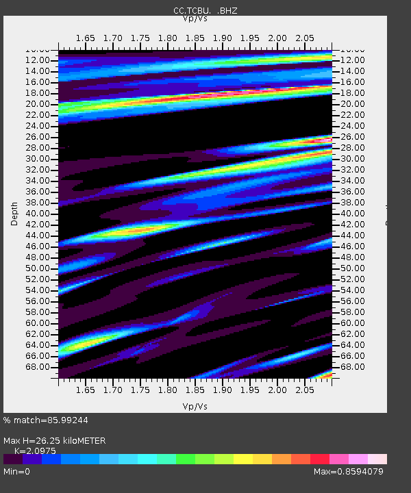
| Estimated Moho Depth: |
26.25 km |
| Estimated Crust Vp/Vs: |
2.10 |
| Assumed Crust Vp: |
6.597 km/s |
| Estimated Crust Vs: |
3.145 km/s |
| Estimated Crust Poisson's Ratio: |
0.35 |
|
| Radial Match: |
85.99244 % |
| Radial Bump: |
400 |
| Transverse Match: |
76.70863 % |
| Transverse Bump: |
400 |
| SOD ConfigId: |
795072 |
| Insert Time: |
2014-10-01 07:16:25.261 +0000 |
| GWidth: |
2.5 |
| Max Bumps: |
400 |
| Tol: |
0.001 |
|

Signal To Noise
| Channel | StoN | STA | LTA |
| CC:TCBU: :BHZ:20140917T06:26:26.660022Z | 46.26131 | 1.1150016E-5 | 2.410225E-7 |
| CC:TCBU: :BHN:20140917T06:26:26.660022Z | 3.9163034 | 1.4546141E-6 | 3.714253E-7 |
| CC:TCBU: :BHE:20140917T06:26:26.660022Z | 8.034156 | 2.6601108E-6 | 3.311002E-7 |
| Arrivals |
| Ps | 4.5 SECOND |
| PpPs | 12 SECOND |
| PsPs/PpSs | 17 SECOND |


