You are here: Home > Network List > G - GEOSCOPE Stations List
> Station TAOE Taiohae, Marquises islands > Earthquake Result Viewer
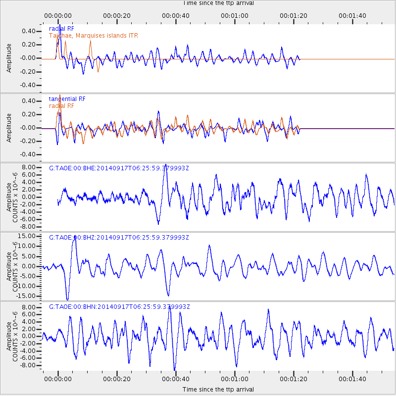
TAOE Taiohae, Marquises islands - Earthquake Result Viewer
*The percent match for this event was below the threshold and hence no stack was calculated.
| Earthquake location: |
Mariana Islands |
| Earthquake latitude/longitude: |
13.8/144.4 |
| Earthquake time(UTC): |
2014/09/17 (260) 06:14:46 GMT |
| Earthquake Depth: |
137 km |
| Earthquake Magnitude: |
6.7 MWC, 7.1 MI |
| Earthquake Catalog/Contributor: |
NEIC PDE/NEIC COMCAT |
|
| Network: |
G GEOSCOPE |
| Station: |
TAOE Taiohae, Marquises islands |
| Lat/Lon: |
8.85 S/140.15 W |
| Elevation: |
800 m |
|
| Distance: |
78.2 deg |
| Az: |
102.224 deg |
| Baz: |
286.063 deg |
| Ray Param: |
$rayparam |
*The percent match for this event was below the threshold and hence was not used in the summary stack. |
|
| Radial Match: |
76.26554 % |
| Radial Bump: |
400 |
| Transverse Match: |
78.00047 % |
| Transverse Bump: |
400 |
| SOD ConfigId: |
795072 |
| Insert Time: |
2014-10-01 07:24:23.982 +0000 |
| GWidth: |
2.5 |
| Max Bumps: |
400 |
| Tol: |
0.001 |
|
Signal To Noise
| Channel | StoN | STA | LTA |
| G:TAOE:00:BHZ:20140917T06:25:59.379993Z | 8.721222 | 7.2414314E-6 | 8.30323E-7 |
| G:TAOE:00:BHN:20140917T06:25:59.379993Z | 2.6612494 | 2.432559E-6 | 9.140665E-7 |
| G:TAOE:00:BHE:20140917T06:25:59.379993Z | 3.520476 | 3.1798595E-6 | 9.03247E-7 |
| Arrivals |
| Ps | |
| PpPs | |
| PsPs/PpSs | |


