You are here: Home > Network List > GO - National Seismic Network of Georgia Stations List
> Station KZRT Kazreti, Georgia > Earthquake Result Viewer
KZRT Kazreti, Georgia - Earthquake Result Viewer
| Earthquake location: |
Mariana Islands |
| Earthquake latitude/longitude: |
13.8/144.4 |
| Earthquake time(UTC): |
2014/09/17 (260) 06:14:46 GMT |
| Earthquake Depth: |
137 km |
| Earthquake Magnitude: |
6.7 MWC, 7.1 MI |
| Earthquake Catalog/Contributor: |
NEIC PDE/NEIC COMCAT |
|
| Network: |
GO National Seismic Network of Georgia |
| Station: |
KZRT Kazreti, Georgia |
| Lat/Lon: |
41.39 N/44.40 E |
| Elevation: |
723 m |
|
| Distance: |
88.4 deg |
| Az: |
312.154 deg |
| Baz: |
73.2 deg |
| Ray Param: |
0.042346414 |
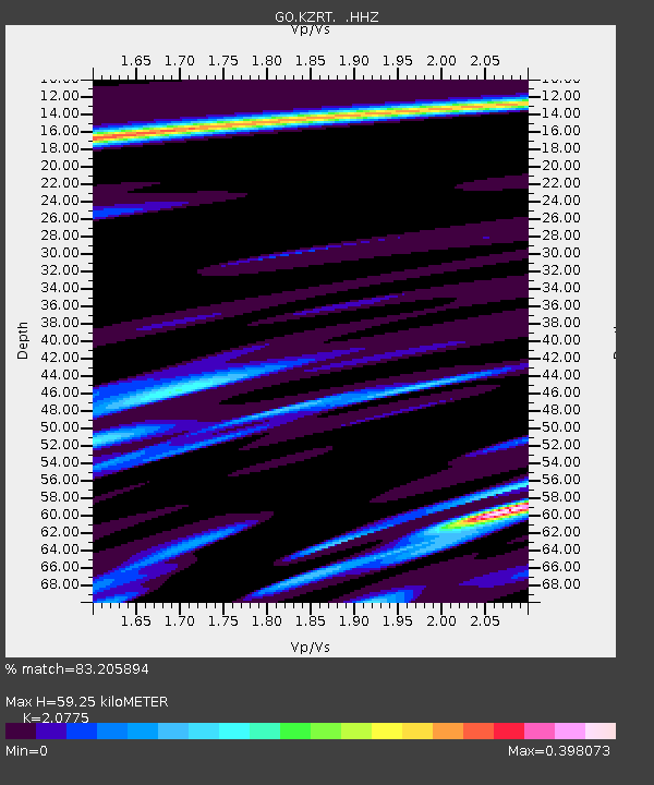
| Estimated Moho Depth: |
59.25 km |
| Estimated Crust Vp/Vs: |
2.08 |
| Assumed Crust Vp: |
6.291 km/s |
| Estimated Crust Vs: |
3.028 km/s |
| Estimated Crust Poisson's Ratio: |
0.35 |
|
| Radial Match: |
83.205894 % |
| Radial Bump: |
259 |
| Transverse Match: |
69.5095 % |
| Transverse Bump: |
400 |
| SOD ConfigId: |
795072 |
| Insert Time: |
2014-10-01 07:25:10.285 +0000 |
| GWidth: |
2.5 |
| Max Bumps: |
400 |
| Tol: |
0.001 |
|

Signal To Noise
| Channel | StoN | STA | LTA |
| GO:KZRT: :HHZ:20140917T06:26:51.330005Z | 9.970583 | 2.4837339E-6 | 2.4910617E-7 |
| GO:KZRT: :HHN:20140917T06:26:51.330005Z | 2.167259 | 4.7286287E-7 | 2.1818475E-7 |
| GO:KZRT: :HHE:20140917T06:26:51.330005Z | 2.2503066 | 6.8111336E-7 | 3.026758E-7 |
| Arrivals |
| Ps | 10 SECOND |
| PpPs | 28 SECOND |
| PsPs/PpSs | 39 SECOND |


