You are here: Home > Network List > IC - New China Digital Seismograph Network Stations List
> Station WMQ Urumqi, Xinjiang Province, China > Earthquake Result Viewer
WMQ Urumqi, Xinjiang Province, China - Earthquake Result Viewer
| Earthquake location: |
Mariana Islands |
| Earthquake latitude/longitude: |
13.8/144.4 |
| Earthquake time(UTC): |
2014/09/17 (260) 06:14:46 GMT |
| Earthquake Depth: |
137 km |
| Earthquake Magnitude: |
6.7 MWC, 7.1 MI |
| Earthquake Catalog/Contributor: |
NEIC PDE/NEIC COMCAT |
|
| Network: |
IC New China Digital Seismograph Network |
| Station: |
WMQ Urumqi, Xinjiang Province, China |
| Lat/Lon: |
43.81 N/87.70 E |
| Elevation: |
850 m |
|
| Distance: |
56.7 deg |
| Az: |
313.615 deg |
| Baz: |
103.641 deg |
| Ray Param: |
0.063551545 |
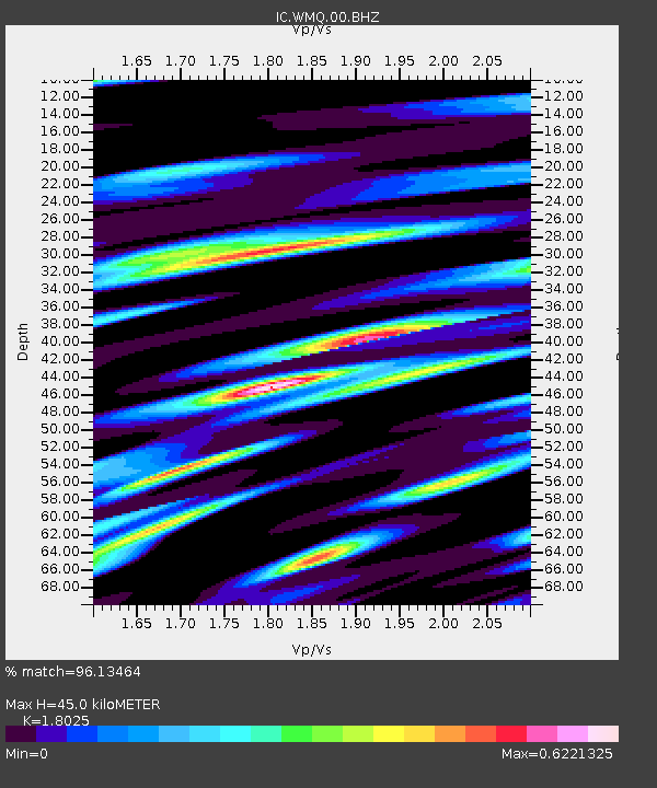
| Estimated Moho Depth: |
45.0 km |
| Estimated Crust Vp/Vs: |
1.80 |
| Assumed Crust Vp: |
6.242 km/s |
| Estimated Crust Vs: |
3.463 km/s |
| Estimated Crust Poisson's Ratio: |
0.28 |
|
| Radial Match: |
96.13464 % |
| Radial Bump: |
400 |
| Transverse Match: |
91.87776 % |
| Transverse Bump: |
400 |
| SOD ConfigId: |
795072 |
| Insert Time: |
2014-10-01 07:27:42.252 +0000 |
| GWidth: |
2.5 |
| Max Bumps: |
400 |
| Tol: |
0.001 |
|
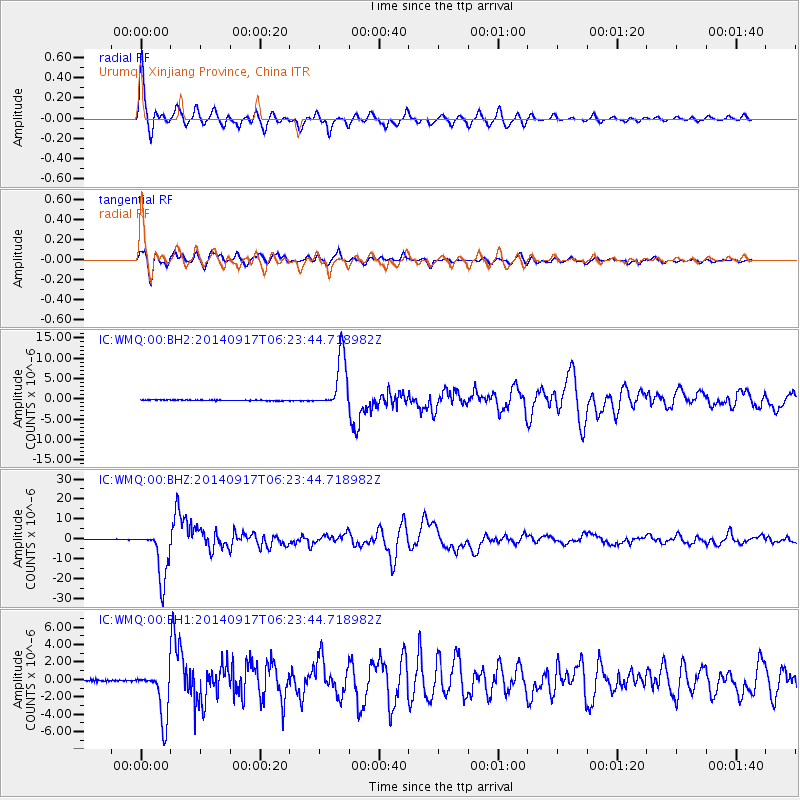
Signal To Noise
| Channel | StoN | STA | LTA |
| IC:WMQ:00:BHZ:20140917T06:23:44.718982Z | 105.47898 | 1.254059E-5 | 1.1889185E-7 |
| IC:WMQ:00:BH1:20140917T06:23:44.718982Z | 33.415 | 2.851663E-6 | 8.5340815E-8 |
| IC:WMQ:00:BH2:20140917T06:23:44.718982Z | 67.0141 | 6.401065E-6 | 9.551819E-8 |
| Arrivals |
| Ps | 6.1 SECOND |
| PpPs | 19 SECOND |
| PsPs/PpSs | 25 SECOND |


