You are here: Home > Network List > II - Global Seismograph Network (GSN - IRIS/IDA) Stations List
> Station WRAB Tennant Creek, NT, Australia > Earthquake Result Viewer
WRAB Tennant Creek, NT, Australia - Earthquake Result Viewer
| Earthquake location: |
Mariana Islands |
| Earthquake latitude/longitude: |
13.8/144.4 |
| Earthquake time(UTC): |
2014/09/17 (260) 06:14:46 GMT |
| Earthquake Depth: |
137 km |
| Earthquake Magnitude: |
6.7 MWC, 7.1 MI |
| Earthquake Catalog/Contributor: |
NEIC PDE/NEIC COMCAT |
|
| Network: |
II Global Seismograph Network (GSN - IRIS/IDA) |
| Station: |
WRAB Tennant Creek, NT, Australia |
| Lat/Lon: |
19.93 S/134.36 E |
| Elevation: |
366 m |
|
| Distance: |
34.9 deg |
| Az: |
196.652 deg |
| Baz: |
17.215 deg |
| Ray Param: |
0.07704031 |
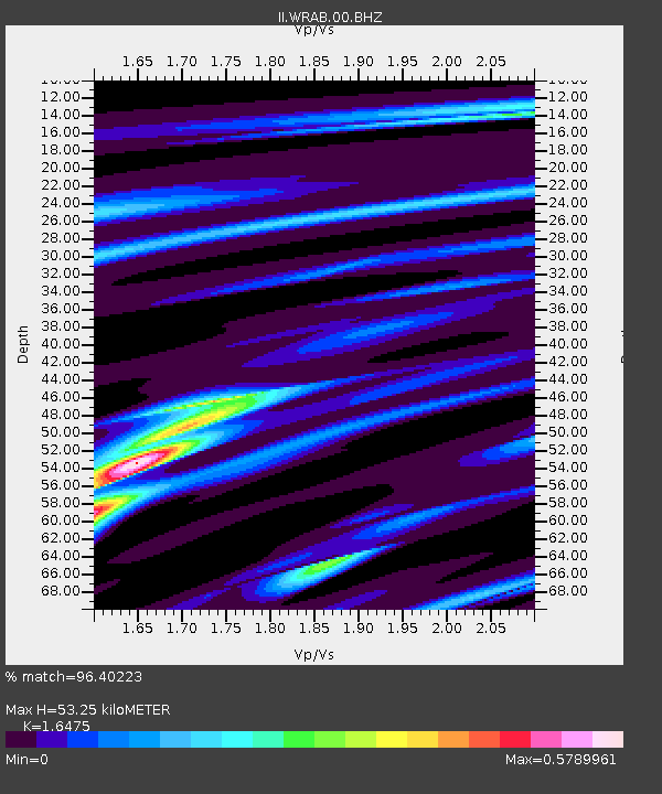
| Estimated Moho Depth: |
53.25 km |
| Estimated Crust Vp/Vs: |
1.65 |
| Assumed Crust Vp: |
6.642 km/s |
| Estimated Crust Vs: |
4.032 km/s |
| Estimated Crust Poisson's Ratio: |
0.21 |
|
| Radial Match: |
96.40223 % |
| Radial Bump: |
166 |
| Transverse Match: |
81.16309 % |
| Transverse Bump: |
400 |
| SOD ConfigId: |
795072 |
| Insert Time: |
2014-10-01 07:28:32.109 +0000 |
| GWidth: |
2.5 |
| Max Bumps: |
400 |
| Tol: |
0.001 |
|
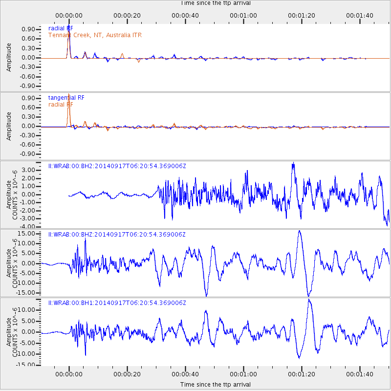
Signal To Noise
| Channel | StoN | STA | LTA |
| II:WRAB:00:BHZ:20140917T06:20:54.369006Z | 12.4205265 | 3.344652E-6 | 2.6928424E-7 |
| II:WRAB:00:BH1:20140917T06:20:54.369006Z | 11.378993 | 2.369009E-6 | 2.0819145E-7 |
| II:WRAB:00:BH2:20140917T06:20:54.369006Z | 4.5500937 | 9.272386E-7 | 2.0378451E-7 |
| Arrivals |
| Ps | 5.7 SECOND |
| PpPs | 19 SECOND |
| PsPs/PpSs | 25 SECOND |


