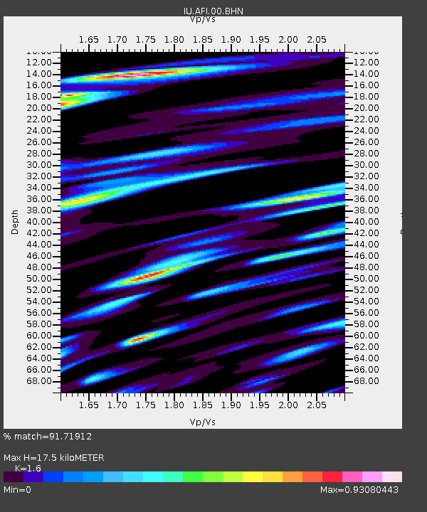
AFI Afiamalu, Western Samoa - Earthquake Result Viewer
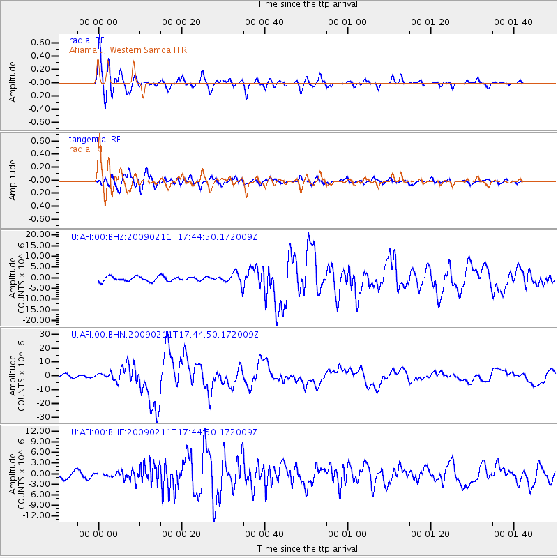
Earthquake location: Talaud Islands, Indonesia
Earthquake latitude/longitude: 3.9/126.4
Earthquake time(UTC): 2009/02/11 (042) 17:34:50 GMT
Earthquake Depth: 22 km
Earthquake Magnitude: 6.6 MB, 7.2 MS, 7.2 MW, 7.1 MW
Earthquake Catalog/Contributor: WHDF/NEIC
Network: IU Global Seismograph Network (GSN - IRIS/USGS)
Station: AFI Afiamalu, Western Samoa
Lat/Lon: 13.91 S/171.78 W
Elevation: 706 m
Distance: 63.8 deg
Az: 107.456 deg
Baz: 281.433 deg
Ray Param: 0.059308503
Estimated Moho Depth: 17.5 km
Estimated Crust Vp/Vs: 1.60
Assumed Crust Vp: 4.24 km/s
Estimated Crust Vs: 2.65 km/s
Estimated Crust Poisson's Ratio: 0.18
Radial Match: 91.71912 %
Radial Bump: 400
Transverse Match: 87.72048 %
Transverse Bump: 400
SOD ConfigId: 2658
Insert Time: 2010-03-02 01:42:24.094 +0000
GWidth: 2.5
Max Bumps: 400
Tol: 0.001

Signal To Noise

ChannelStoNSTALTA
IU:AFI:00:BHN:20090211T17:44:50.172009Z2.37666422.575535E-61.0836765E-6
IU:AFI:00:BHE:20090211T17:44:50.172009Z0.41588894.3717017E-71.0511706E-6
IU:AFI:00:BHZ:20090211T17:44:50.172009Z2.5629752.7458784E-61.0713638E-6
Arrivals
Ps2.5 SECOND
PpPs11 SECOND
PsPs/PpSs13 SECOND