You are here: Home > Network List > IU - Global Seismograph Network (GSN - IRIS/USGS) Stations List
> Station AFI Afiamalu, Samoa > Earthquake Result Viewer
AFI Afiamalu, Samoa - Earthquake Result Viewer
| Earthquake location: |
Mariana Islands |
| Earthquake latitude/longitude: |
13.8/144.4 |
| Earthquake time(UTC): |
2014/09/17 (260) 06:14:46 GMT |
| Earthquake Depth: |
137 km |
| Earthquake Magnitude: |
6.7 MWC, 7.1 MI |
| Earthquake Catalog/Contributor: |
NEIC PDE/NEIC COMCAT |
|
| Network: |
IU Global Seismograph Network (GSN - IRIS/USGS) |
| Station: |
AFI Afiamalu, Samoa |
| Lat/Lon: |
13.91 S/171.78 W |
| Elevation: |
706 m |
|
| Distance: |
51.4 deg |
| Az: |
120.598 deg |
| Baz: |
300.535 deg |
| Ray Param: |
0.066990316 |
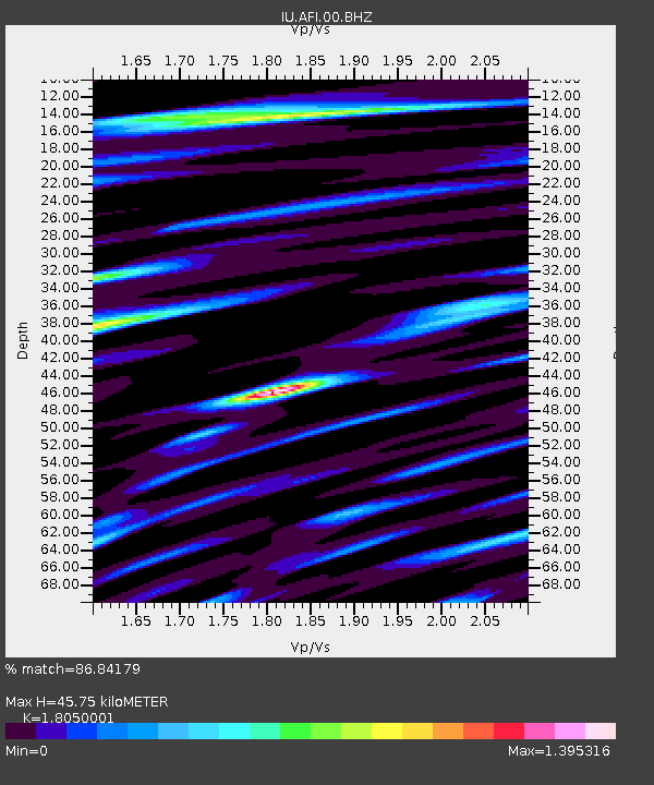
| Estimated Moho Depth: |
45.75 km |
| Estimated Crust Vp/Vs: |
1.81 |
| Assumed Crust Vp: |
4.24 km/s |
| Estimated Crust Vs: |
2.349 km/s |
| Estimated Crust Poisson's Ratio: |
0.28 |
|
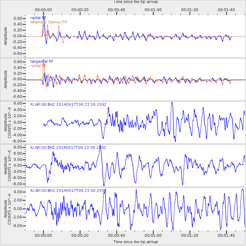
| Radial Match: |
86.84179 % |
| Radial Bump: |
400 |
| Transverse Match: |
76.71307 % |
| Transverse Bump: |
400 |
| SOD ConfigId: |
795072 |
| Insert Time: |
2014-10-01 07:29:01.337 +0000 |
| GWidth: |
2.5 |
| Max Bumps: |
400 |
| Tol: |
0.001 |
|
Signal To Noise
| Channel | StoN | STA | LTA |
| IU:AFI:00:BHZ:20140917T06:23:06.269Z | 4.4753895 | 3.4873112E-6 | 7.7921965E-7 |
| IU:AFI:00:BH1:20140917T06:23:06.269Z | 1.7076005 | 1.218619E-6 | 7.136441E-7 |
| IU:AFI:00:BH2:20140917T06:23:06.269Z | 3.683363 | 2.1490305E-6 | 5.834425E-7 |
| Arrivals |
| Ps | 8.9 SECOND |
| PpPs | 30 SECOND |
| PsPs/PpSs | 38 SECOND |


