You are here: Home > Network List > IU - Global Seismograph Network (GSN - IRIS/USGS) Stations List
> Station AFI Afiamalu, Western Samoa > Earthquake Result Viewer
AFI Afiamalu, Western Samoa - Earthquake Result Viewer
| Earthquake location: |
Central Alaska |
| Earthquake latitude/longitude: |
63.5/-147.4 |
| Earthquake time(UTC): |
2002/11/03 (307) 22:12:41 GMT |
| Earthquake Depth: |
4.9 km |
| Earthquake Magnitude: |
7.0 MB, 8.5 MS, 7.9 MW |
| Earthquake Catalog/Contributor: |
WHDF/NEIC |
|
| Network: |
IU Global Seismograph Network (GSN - IRIS/USGS) |
| Station: |
AFI Afiamalu, Western Samoa |
| Lat/Lon: |
13.91 S/171.78 W |
| Elevation: |
706 m |
|
| Distance: |
79.4 deg |
| Az: |
204.017 deg |
| Baz: |
10.831 deg |
| Ray Param: |
0.04896479 |
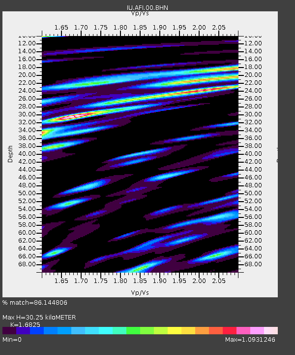
| Estimated Moho Depth: |
30.25 km |
| Estimated Crust Vp/Vs: |
1.68 |
| Assumed Crust Vp: |
4.24 km/s |
| Estimated Crust Vs: |
2.52 km/s |
| Estimated Crust Poisson's Ratio: |
0.23 |
|
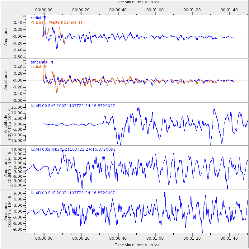
| Radial Match: |
86.144806 % |
| Radial Bump: |
400 |
| Transverse Match: |
67.34444 % |
| Transverse Bump: |
400 |
| SOD ConfigId: |
4714 |
| Insert Time: |
2010-03-02 01:42:29.307 +0000 |
| GWidth: |
2.5 |
| Max Bumps: |
400 |
| Tol: |
0.001 |
|
Signal To Noise
| Channel | StoN | STA | LTA |
| IU:AFI:00:BHN:20021103T22:24:16.872009Z | 2.4375603 | 2.7543404E-6 | 1.1299579E-6 |
| IU:AFI:00:BHE:20021103T22:24:16.872009Z | 0.79696465 | 9.3849366E-7 | 1.1775851E-6 |
| IU:AFI:00:BHZ:20021103T22:24:16.872009Z | 6.1232677 | 3.2147238E-6 | 5.250014E-7 |
| Arrivals |
| Ps | 4.9 SECOND |
| PpPs | 19 SECOND |
| PsPs/PpSs | 24 SECOND |


