You are here: Home > Network List > IU - Global Seismograph Network (GSN - IRIS/USGS) Stations List
> Station KBL Kabul, Afghanistan > Earthquake Result Viewer
KBL Kabul, Afghanistan - Earthquake Result Viewer
| Earthquake location: |
Mariana Islands |
| Earthquake latitude/longitude: |
13.8/144.4 |
| Earthquake time(UTC): |
2014/09/17 (260) 06:14:46 GMT |
| Earthquake Depth: |
137 km |
| Earthquake Magnitude: |
6.7 MWC, 7.1 MI |
| Earthquake Catalog/Contributor: |
NEIC PDE/NEIC COMCAT |
|
| Network: |
IU Global Seismograph Network (GSN - IRIS/USGS) |
| Station: |
KBL Kabul, Afghanistan |
| Lat/Lon: |
34.54 N/69.04 E |
| Elevation: |
1920 m |
|
| Distance: |
70.4 deg |
| Az: |
302.002 deg |
| Baz: |
86.568 deg |
| Ray Param: |
0.054676384 |
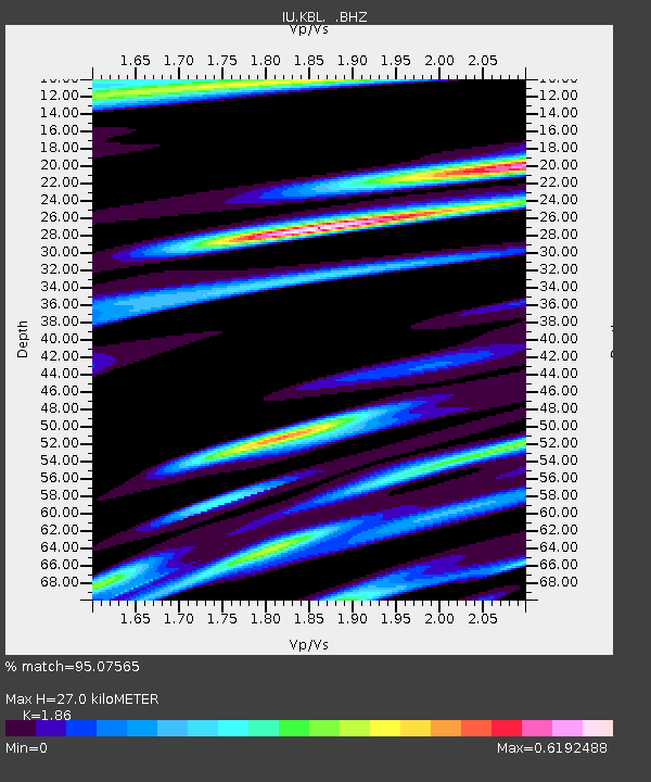
| Estimated Moho Depth: |
27.0 km |
| Estimated Crust Vp/Vs: |
1.86 |
| Assumed Crust Vp: |
6.641 km/s |
| Estimated Crust Vs: |
3.57 km/s |
| Estimated Crust Poisson's Ratio: |
0.30 |
|
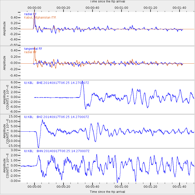
| Radial Match: |
95.07565 % |
| Radial Bump: |
400 |
| Transverse Match: |
92.88991 % |
| Transverse Bump: |
400 |
| SOD ConfigId: |
795072 |
| Insert Time: |
2014-10-01 07:29:22.477 +0000 |
| GWidth: |
2.5 |
| Max Bumps: |
400 |
| Tol: |
0.001 |
|
Signal To Noise
| Channel | StoN | STA | LTA |
| IU:KBL: :BHZ:20140917T06:25:14.270007Z | 105.052536 | 7.784704E-6 | 7.4102964E-8 |
| IU:KBL: :BHN:20140917T06:25:14.270007Z | 26.862265 | 9.4172486E-7 | 3.505754E-8 |
| IU:KBL: :BHE:20140917T06:25:14.270007Z | 69.268684 | 3.2980818E-6 | 4.7612883E-8 |
| Arrivals |
| Ps | 3.6 SECOND |
| PpPs | 11 SECOND |
| PsPs/PpSs | 15 SECOND |


