You are here: Home > Network List > IU - Global Seismograph Network (GSN - IRIS/USGS) Stations List
> Station MAKZ Makanchi, Kazakhstan > Earthquake Result Viewer
MAKZ Makanchi, Kazakhstan - Earthquake Result Viewer
| Earthquake location: |
Mariana Islands |
| Earthquake latitude/longitude: |
13.8/144.4 |
| Earthquake time(UTC): |
2014/09/17 (260) 06:14:46 GMT |
| Earthquake Depth: |
137 km |
| Earthquake Magnitude: |
6.7 MWC, 7.1 MI |
| Earthquake Catalog/Contributor: |
NEIC PDE/NEIC COMCAT |
|
| Network: |
IU Global Seismograph Network (GSN - IRIS/USGS) |
| Station: |
MAKZ Makanchi, Kazakhstan |
| Lat/Lon: |
46.81 N/81.98 E |
| Elevation: |
600 m |
|
| Distance: |
61.3 deg |
| Az: |
316.026 deg |
| Baz: |
100.823 deg |
| Ray Param: |
0.06058902 |
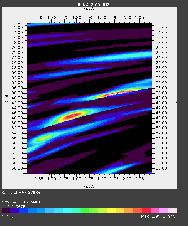
| Estimated Moho Depth: |
38.0 km |
| Estimated Crust Vp/Vs: |
1.96 |
| Assumed Crust Vp: |
6.571 km/s |
| Estimated Crust Vs: |
3.348 km/s |
| Estimated Crust Poisson's Ratio: |
0.32 |
|
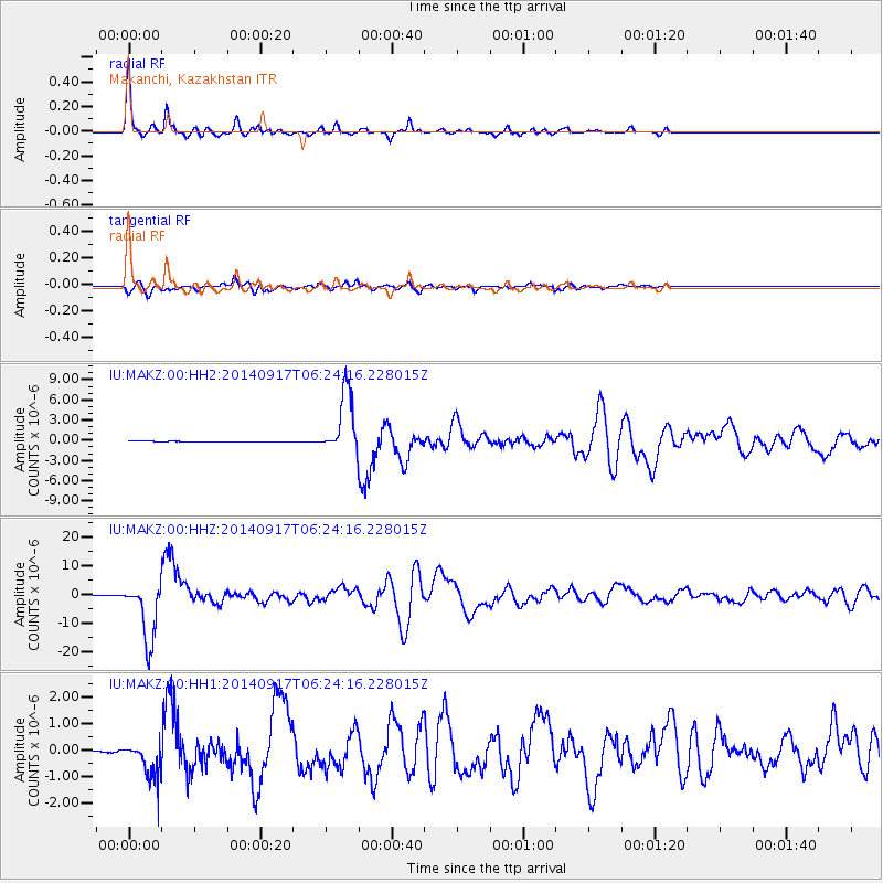
| Radial Match: |
97.57936 % |
| Radial Bump: |
285 |
| Transverse Match: |
90.514595 % |
| Transverse Bump: |
400 |
| SOD ConfigId: |
795072 |
| Insert Time: |
2014-10-01 07:29:28.070 +0000 |
| GWidth: |
2.5 |
| Max Bumps: |
400 |
| Tol: |
0.001 |
|
Signal To Noise
| Channel | StoN | STA | LTA |
| IU:MAKZ:00:HHZ:20140917T06:24:16.228015Z | 157.87347 | 1.0477253E-5 | 6.6364876E-8 |
| IU:MAKZ:00:HH1:20140917T06:24:16.228015Z | 20.800526 | 6.827907E-7 | 3.2825646E-8 |
| IU:MAKZ:00:HH2:20140917T06:24:16.228015Z | 115.978584 | 4.6235127E-6 | 3.9865228E-8 |
| Arrivals |
| Ps | 5.8 SECOND |
| PpPs | 16 SECOND |
| PsPs/PpSs | 22 SECOND |


