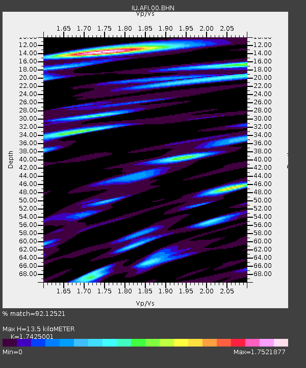
AFI Afiamalu, Western Samoa - Earthquake Result Viewer
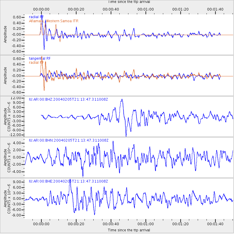
Earthquake location: Irian Jaya Region, Indonesia
Earthquake latitude/longitude: -3.6/135.5
Earthquake time(UTC): 2004/02/05 (036) 21:05:02 GMT
Earthquake Depth: 17 km
Earthquake Magnitude: 6.1 MB, 7.1 MS, 7.0 MW, 6.8 MW
Earthquake Catalog/Contributor: WHDF/NEIC
Network: IU Global Seismograph Network (GSN - IRIS/USGS)
Station: AFI Afiamalu, Western Samoa
Lat/Lon: 13.91 S/171.78 W
Elevation: 706 m
Distance: 53.0 deg
Az: 104.625 deg
Baz: 276.019 deg
Ray Param: 0.066407934
Estimated Moho Depth: 13.5 km
Estimated Crust Vp/Vs: 1.74
Assumed Crust Vp: 4.24 km/s
Estimated Crust Vs: 2.433 km/s
Estimated Crust Poisson's Ratio: 0.25
Radial Match: 92.12521 %
Radial Bump: 400
Transverse Match: 69.50177 %
Transverse Bump: 400
SOD ConfigId: 2459
Insert Time: 2010-03-02 01:42:42.118 +0000
GWidth: 2.5
Max Bumps: 400
Tol: 0.001

Signal To Noise

ChannelStoNSTALTA
IU:AFI:00:BHN:20040205T21:13:47.311008Z1.07363571.0810214E-61.0068793E-6
IU:AFI:00:BHE:20040205T21:13:47.311008Z2.72834521.3953062E-65.1141114E-7
IU:AFI:00:BHZ:20040205T21:13:47.311008Z2.64034061.7324913E-66.561621E-7
Arrivals
Ps2.4 SECOND
PpPs8.5 SECOND
PsPs/PpSs11 SECOND