You are here: Home > Network List > IU - Global Seismograph Network (GSN - IRIS/USGS) Stations List
> Station AFI Afiamalu, Western Samoa > Earthquake Result Viewer
AFI Afiamalu, Western Samoa - Earthquake Result Viewer
| Earthquake location: |
Macquarie Island Region |
| Earthquake latitude/longitude: |
-55.7/158.5 |
| Earthquake time(UTC): |
2008/04/12 (103) 00:30:12 GMT |
| Earthquake Depth: |
16 km |
| Earthquake Magnitude: |
6.8 MB, 7.1 MS, 7.1 MW, 7.1 MW |
| Earthquake Catalog/Contributor: |
WHDF/NEIC |
|
| Network: |
IU Global Seismograph Network (GSN - IRIS/USGS) |
| Station: |
AFI Afiamalu, Western Samoa |
| Lat/Lon: |
13.91 S/171.78 W |
| Elevation: |
706 m |
|
| Distance: |
47.6 deg |
| Az: |
40.769 deg |
| Baz: |
202.398 deg |
| Ray Param: |
0.06987629 |
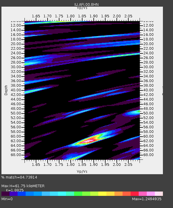
| Estimated Moho Depth: |
61.75 km |
| Estimated Crust Vp/Vs: |
1.88 |
| Assumed Crust Vp: |
4.24 km/s |
| Estimated Crust Vs: |
2.252 km/s |
| Estimated Crust Poisson's Ratio: |
0.30 |
|
| Radial Match: |
84.73914 % |
| Radial Bump: |
400 |
| Transverse Match: |
69.67791 % |
| Transverse Bump: |
400 |
| SOD ConfigId: |
2504 |
| Insert Time: |
2010-03-02 01:42:58.325 +0000 |
| GWidth: |
2.5 |
| Max Bumps: |
400 |
| Tol: |
0.001 |
|
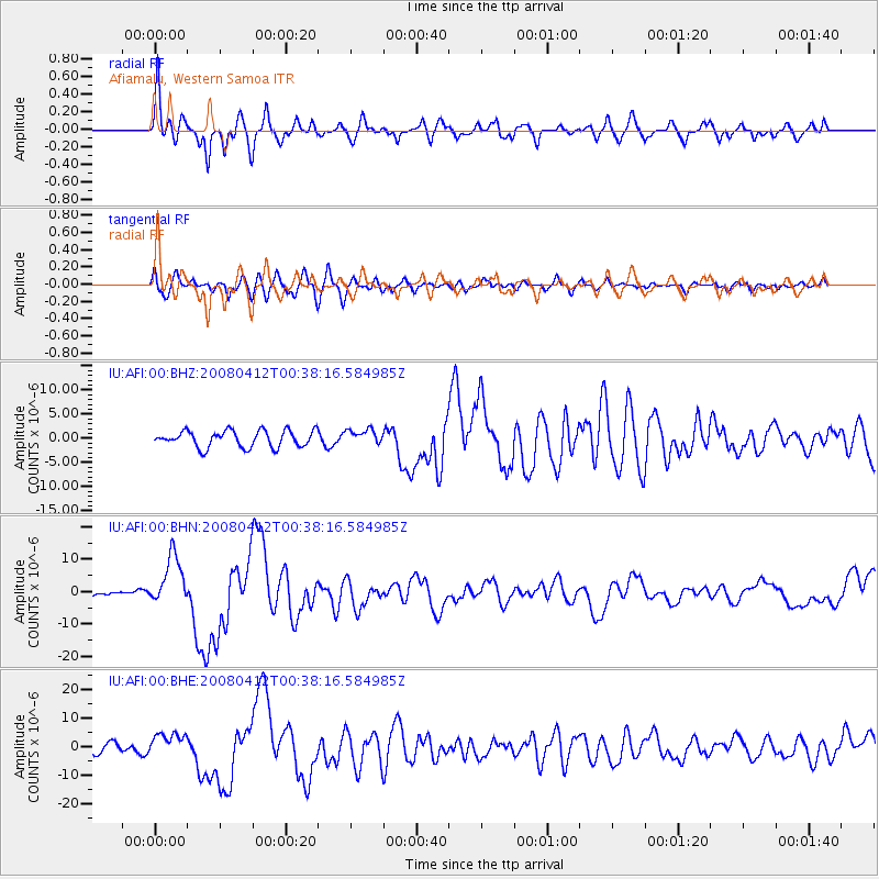
Signal To Noise
| Channel | StoN | STA | LTA |
| IU:AFI:00:BHN:20080412T00:38:16.584985Z | 8.049637 | 7.71483E-6 | 9.584072E-7 |
| IU:AFI:00:BHE:20080412T00:38:16.584985Z | 2.2292795 | 4.151444E-6 | 1.8622359E-6 |
| IU:AFI:00:BHZ:20080412T00:38:16.584985Z | 0.90337443 | 1.5405132E-6 | 1.7052876E-6 |
| Arrivals |
| Ps | 13 SECOND |
| PpPs | 41 SECOND |
| PsPs/PpSs | 54 SECOND |


