You are here: Home > Network List > IU - Global Seismograph Network (GSN - IRIS/USGS) Stations List
> Station AFI Afiamalu, Western Samoa > Earthquake Result Viewer
AFI Afiamalu, Western Samoa - Earthquake Result Viewer
| Earthquake location: |
East Of Kuril Islands |
| Earthquake latitude/longitude: |
46.9/155.2 |
| Earthquake time(UTC): |
2009/01/15 (015) 17:49:39 GMT |
| Earthquake Depth: |
36 km |
| Earthquake Magnitude: |
6.9 MB, 7.5 MS, 7.4 MW, 7.4 MW |
| Earthquake Catalog/Contributor: |
WHDF/NEIC |
|
| Network: |
IU Global Seismograph Network (GSN - IRIS/USGS) |
| Station: |
AFI Afiamalu, Western Samoa |
| Lat/Lon: |
13.91 S/171.78 W |
| Elevation: |
706 m |
|
| Distance: |
67.4 deg |
| Az: |
144.968 deg |
| Baz: |
336.066 deg |
| Ray Param: |
0.056938976 |
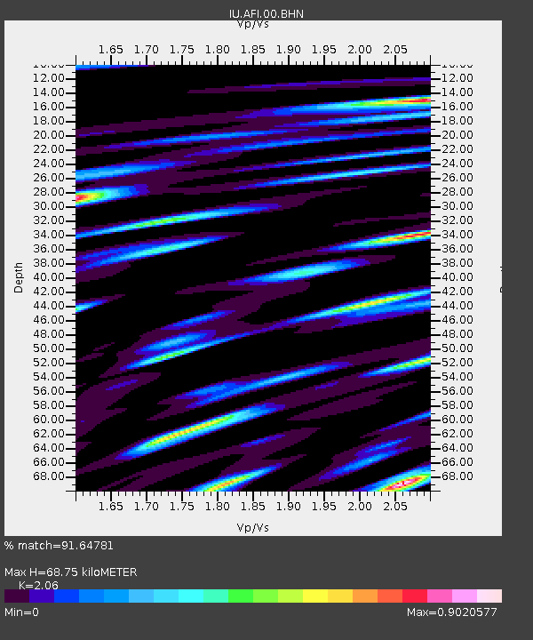
| Estimated Moho Depth: |
68.75 km |
| Estimated Crust Vp/Vs: |
2.06 |
| Assumed Crust Vp: |
4.24 km/s |
| Estimated Crust Vs: |
2.058 km/s |
| Estimated Crust Poisson's Ratio: |
0.35 |
|
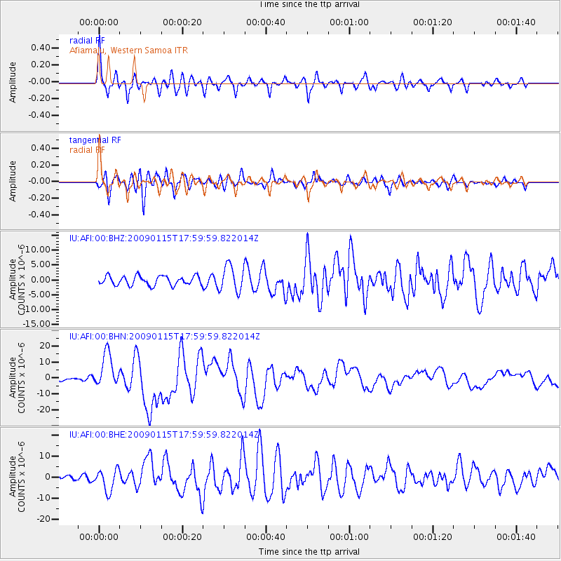
| Radial Match: |
91.64781 % |
| Radial Bump: |
400 |
| Transverse Match: |
77.50409 % |
| Transverse Bump: |
400 |
| SOD ConfigId: |
2834 |
| Insert Time: |
2010-03-02 01:43:17.246 +0000 |
| GWidth: |
2.5 |
| Max Bumps: |
400 |
| Tol: |
0.001 |
|
Signal To Noise
| Channel | StoN | STA | LTA |
| IU:AFI:00:BHN:20090115T17:59:59.822014Z | 6.4179006 | 1.11444215E-5 | 1.7364591E-6 |
| IU:AFI:00:BHE:20090115T17:59:59.822014Z | 2.8078954 | 5.4229267E-6 | 1.9313138E-6 |
| IU:AFI:00:BHZ:20090115T17:59:59.822014Z | 2.8887868 | 4.4380577E-6 | 1.5363049E-6 |
| Arrivals |
| Ps | 17 SECOND |
| PpPs | 49 SECOND |
| PsPs/PpSs | 66 SECOND |


