You are here: Home > Network List > S - Seismographs in Schools Projects Stations List
> Station AUMTS Mt Stromlo, ANU > Earthquake Result Viewer
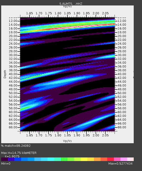
AUMTS Mt Stromlo, ANU - Earthquake Result Viewer
| Earthquake location: |
Mariana Islands |
| Earthquake latitude/longitude: |
13.8/144.4 |
| Earthquake time(UTC): |
2014/09/17 (260) 06:14:46 GMT |
| Earthquake Depth: |
137 km |
| Earthquake Magnitude: |
6.7 MWC, 7.1 MI |
| Earthquake Catalog/Contributor: |
NEIC PDE/NEIC COMCAT |
|
| Network: |
S Seismographs in Schools Projects |
| Station: |
AUMTS Mt Stromlo, ANU |
| Lat/Lon: |
35.32 S/149.00 E |
| Elevation: |
667 m |
|
| Distance: |
49.0 deg |
| Az: |
175.015 deg |
| Baz: |
354.074 deg |
| Ray Param: |
0.068514004 |
| Estimated Moho Depth: |
14.75 km |
| Estimated Crust Vp/Vs: |
1.91 |
| Assumed Crust Vp: |
6.633 km/s |
| Estimated Crust Vs: |
3.478 km/s |
| Estimated Crust Poisson's Ratio: |
0.31 |
|
| Radial Match: |
89.24092 % |
| Radial Bump: |
269 |
| Transverse Match: |
71.06168 % |
| Transverse Bump: |
400 |
| SOD ConfigId: |
795072 |
| Insert Time: |
2014-10-01 07:54:06.687 +0000 |
| GWidth: |
2.5 |
| Max Bumps: |
400 |
| Tol: |
0.001 |
|

Signal To Noise
| Channel | StoN | STA | LTA |
| S:AUMTS: :HHZ:20140917T06:22:48.430011Z | 2.1524081 | 3.743323E-6 | 1.7391326E-6 |
| S:AUMTS: :HHN:20140917T06:22:48.430011Z | 1.7965597 | 2.2810775E-6 | 1.269692E-6 |
| S:AUMTS: :HHE:20140917T06:22:48.430011Z | 1.2302929 | 1.4728627E-6 | 1.1971641E-6 |
| Arrivals |
| Ps | 2.1 SECOND |
| PpPs | 6.1 SECOND |
| PsPs/PpSs | 8.2 SECOND |


